Cihuela geodata
Cihuela (Castille and León) is a seat of a third-order administrative division; located in Spain in Europe/Madrid (GMT+2) time zone. With population of 80 people, there are 6136 cities with bigger population in this country. Compared to other cities in Spain, 58% of cities are located further ↓South; 67.5% of cities are located further ←West and 71.2% of cities have lower elevation than Cihuela. Note1


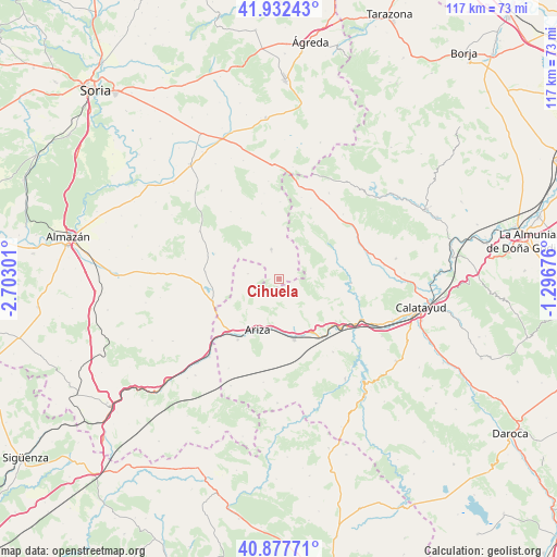
Cihuela GPS coordinates[2]
41° 24' 25.956" North, 1° 59' 59.604" West
| Map corner | latitude | longitude |
|---|---|---|
| Upper-left | 41.93243°, | -2.70301° |
| Center: | 41.40721°, | -1.99989° |
| Lower-right: | 40.87771°, | -1.29676° |
| Map W x H: | 117.3×117.3 km | = 72.9×72.9mi |
| max Lat: | 43.74134° ⇑42% North |
| Cihuela: | 41.40721° |
| min Lat: | ⇓58% South 27.64134° |
| min Long | Cihuela | max Long |
| -18.00367° | -1.99989° | 4.2899° |
| W 67.5%⇐ | ⇒32.5% E |
Elevation
Elevation of Cihuela is 822 m = 2697 ft, and this is 224 m = 735 ft above average elevation for this country.
| Max E: |
1682 m = 5518 ft | 28.8% |
| Cihuela | 822 m 2697 ft | |
| Avg. | 598 m = 1962 ft | |
Min E: |
0 m = 0 ft | 71.2% |
See also: Spain elevation on elevation.city.
Geographical zone
Cihuela is located in North temperate zone (between Tropic of Cancer and the Arctic Circle). Distance of this Northern Tropic circle is 1998.1 km =1241.6 mi to South.| Distance of | km | miles | from Cihuela |
|---|---|---|---|
| North Pole | 5403 | 3357.3 | to North |
| Arctic Circle | 2797.1 | 1738 | to North |
| Tropic Cancer | 1998.1 | 1241.6 | to South |
| Equator | 4604.1 | 2860.9 | to South |


Nearby cities:
15 places around Cihuela: (largest is in red/bold)
• Alhama de Aragón
15.2 km =9.4 mi,  144°
144°
• Ariza
11.2 km =7 mi,  203°
203°
• Bordalba
5.7 km =3.5 mi,  280°
280°
• Bubierca
15.9 km =9.9 mi,  130°
130°
• Cetina
13.2 km =8.2 mi,  166°
166°
• Contamina
13.3 km =8.3 mi,  148°
148°
• Deza
6.5 km =4 mi,  344°
344°
• Embid de Ariza
3.9 km =2.4 mi, 145°
• Monreal de Ariza
15.6 km =9.7 mi,  214°
214°
• Monteagudo de las Vicarías
14.9 km =9.3 mi,  251°
251°
• Moros
14.3 km =8.9 mi,  94°
94°
• Pozuel de Ariza
14 km =8.7 mi,  243°
243°
• Torlengua
14.5 km =9 mi,  291°
291°
• Torrijo de la Cañada
12.8 km =8 mi,  55°
55°
• Villalengua
13.6 km =8.5 mi,  76°
76°
Sources, notices
• [Note1] Compared only with cities in Spain existing in our database
• [Src1] Map data: © OpenStreetMap contributors (CC-BY-SA)
• [Src2] Other city data from geonames.org with taken over terms of usage.
• [Src3] Geographical zone / Annual Mean Temperature by Robert A. Rohde @ Wikipedia
