Embid de Ariza geodata
Embid de Ariza (Aragon) is a seat of a third-order administrative division; located in Spain in Europe/Madrid (GMT+2) time zone. With population of 75 people, there are 6194 cities with bigger population in this country. Compared to other cities in Spain, 57% of cities are located further ↓South; 67.8% of cities are located further ←West and 63.6% of cities have lower elevation than Embid de Ariza. Note1


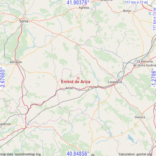
Embid de Ariza GPS coordinates[2]
41° 22' 41.88" North, 1° 58' 25.428" West
| Map corner | latitude | longitude |
|---|---|---|
| Upper-left | 41.90376°, | -2.67685° |
| Center: | 41.3783°, | -1.97373° |
| Lower-right: | 40.84856°, | -1.2706° |
| Map W x H: | 117.3×117.3 km | = 72.9×72.9mi |
| max Lat: | 43.74134° ⇑43% North |
| Embid de Ariza: | 41.3783° |
| min Lat: | ⇓57% South 27.64134° |
| min Long | Embid de Ariza | max Long |
| -18.00367° | -1.97373° | 4.2899° |
| W 67.8%⇐ | ⇒32.2% E |
Elevation
Elevation of Embid de Ariza is 768 m = 2520 ft, and this is 170 m = 558 ft above average elevation for this country.
| Max E: |
1682 m = 5518 ft | 36.4% |
| Embid de Ariza | 768 m 2520 ft | |
| Avg. | 598 m = 1962 ft | |
Min E: |
0 m = 0 ft | 63.6% |
See also: Spain elevation on elevation.city.
Geographical zone
Embid de Ariza is located in North temperate zone (between Tropic of Cancer and the Arctic Circle). Distance of this Northern Tropic circle is 1994.9 km =1239.6 mi to South.| Distance of | km | miles | from Embid de Ariza |
|---|---|---|---|
| North Pole | 5406.2 | 3359.3 | to North |
| Arctic Circle | 2800.3 | 1740 | to North |
| Tropic Cancer | 1994.9 | 1239.6 | to South |
| Equator | 4600.8 | 2858.8 | to South |


Nearby cities:
15 places around Embid de Ariza: (largest is in red/bold)
• Alhama de Aragón
11.3 km =7 mi,  143°
143°
• Ariza
9.7 km =6 mi,  223°
223°
• Bordalba
8.8 km =5.5 mi,  298°
298°
• Bubierca
12.2 km =7.6 mi,  125°
125°
• Castejón de las Armas
15.6 km =9.7 mi,  119°
119°
• Cetina
9.6 km =6 mi,  174°
174°
• Cihuela
3.9 km =2.4 mi,  325°
325°
• Contamina
9.4 km =5.8 mi,  149°
149°
• Deza
10.3 km =6.4 mi,  337°
337°
• Godojos
15.3 km =9.5 mi, 143°
• Monreal de Ariza
14.6 km =9.1 mi,  228°
228°
• Moros
12.3 km =7.6 mi,  79°
79°
• Pozuel de Ariza
15 km =9.3 mi,  257°
257°
• Torrijo de la Cañada
13.4 km =8.3 mi,  38°
38°
• Villalengua
12.7 km =7.9 mi,  60°
60°
Sources, notices
• [Note1] Compared only with cities in Spain existing in our database
• [Src1] Map data: © OpenStreetMap contributors (CC-BY-SA)
• [Src2] Other city data from geonames.org with taken over terms of usage.
• [Src3] Geographical zone / Annual Mean Temperature by Robert A. Rohde @ Wikipedia
