Bubierca geodata
Bubierca (Aragon) is a seat of a third-order administrative division; located in Spain in Europe/Madrid (GMT+2) time zone. With population of 91 people, there are 6042 cities with bigger population in this country. Compared to other cities in Spain, 55.6% of cities are located further ↓South; 69% of cities are located further ←West and 50.3% of cities have lower elevation than Bubierca. Note1


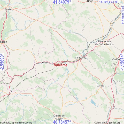
Bubierca GPS coordinates[2]
41° 18' 53.352" North, 1° 51' 13.896" West
| Map corner | latitude | longitude |
|---|---|---|
| Upper-left | 41.84079°, | -2.55699° |
| Center: | 41.31482°, | -1.85386° |
| Lower-right: | 40.78457°, | -1.15074° |
| Map W x H: | 117.4×117.4 km | = 72.9×72.9mi |
| max Lat: | 43.74134° ⇑44.4% North |
| Bubierca: | 41.31482° |
| min Lat: | ⇓55.6% South 27.64134° |
| min Long | Bubierca | max Long |
| -18.00367° | -1.85386° | 4.2899° |
| W 69%⇐ | ⇒31% E |
Elevation
Elevation of Bubierca is 662 m = 2172 ft, and this is 64 m = 210 ft above average elevation for this country.
| Max E: |
1682 m = 5518 ft | 49.7% |
| Bubierca | 662 m 2172 ft | |
| Avg. | 598 m = 1962 ft | |
Min E: |
0 m = 0 ft | 50.3% |
See also: Spain elevation on elevation.city.
Geographical zone
Bubierca is located in North temperate zone (between Tropic of Cancer and the Arctic Circle). Distance of this Northern Tropic circle is 1987.9 km =1235.2 mi to South.| Distance of | km | miles | from Bubierca |
|---|---|---|---|
| North Pole | 5413.3 | 3363.7 | to North |
| Arctic Circle | 2807.4 | 1744.4 | to North |
| Tropic Cancer | 1987.9 | 1235.2 | to South |
| Equator | 4593.8 | 2854.5 | to South |


Nearby cities:
15 places around Bubierca: (largest is in red/bold)
• Alhama de Aragón
3.9 km =2.4 mi,  238°
238°
• Ateca
5.3 km =3.3 mi,  70°
70°
• Carenas
6.3 km =3.9 mi,  131°
131°
• Castejón de las Armas
3.6 km =2.2 mi,  98°
98°
• Cetina
9.4 km =5.8 mi,  254°
254°
• Contamina
5.4 km =3.4 mi,  258°
258°
• Embid de Ariza
12.2 km =7.6 mi,  305°
305°
• Godojos
5.2 km =3.2 mi,  189°
189°
• Ibdes
11 km =6.8 mi,  171°
171°
• Jaraba
14 km =8.7 mi, 190°
• Moros
9.5 km =5.9 mi,  12°
12°
• Nuévalos
12.6 km =7.8 mi,  154°
154°
• Terrer
11.8 km =7.3 mi,  82°
82°
• Valtorres
9.6 km =6 mi, 100°
• Villalengua
13.5 km =8.4 mi,  4°
4°
Sources, notices
• [Note1] Compared only with cities in Spain existing in our database
• [Src1] Map data: © OpenStreetMap contributors (CC-BY-SA)
• [Src2] Other city data from geonames.org with taken over terms of usage.
• [Src3] Geographical zone / Annual Mean Temperature by Robert A. Rohde @ Wikipedia
