Cervo geodata
Cervo (Galicia) is a seat of a third-order administrative division; located in Spain in Europe/Madrid (GMT+2) time zone. With population of 4,908 people, there are 1326 cities with bigger population in this country. Compared to other cities in Spain, 100% of cities are located further ↓South; 95.3% of cities are located further →East and 90.1% of cities have higher elevation than Cervo. Note1


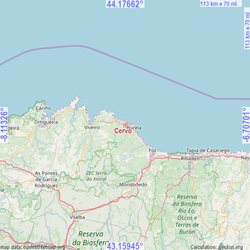
Cervo GPS coordinates[2]
43° 40' 12.684" North, 7° 24' 36.468" West
| Map corner | latitude | longitude |
|---|---|---|
| Upper-left | 44.17662°, | -8.11326° |
| Center: | 43.67019°, | -7.41013° |
| Lower-right: | 43.15945°, | -6.70701° |
| Map W x H: | 113.1×113.1 km | = 70.3×70.3mi |
| max Lat: | 43.74134° ⇑0% North |
| Cervo: | 43.67019° |
| min Lat: | ⇓100% South 27.64134° |
| min Long | Cervo | max Long |
| -18.00367° | -7.41013° | 4.2899° |
| W 4.7%⇐ | ⇒95.3% E |
Elevation
Elevation of Cervo is 64 m = 210 ft, and this is 534 m = 1752 ft below average elevation for this country.
| Max E: |
1682 m = 5518 ft | 90.1% |
| Avg. | 598 m = 1962 ft | |
| Cervo | 64 m = 210 ft | |
Min E: |
0 m = 0 ft | 9.9% |
See also: Spain elevation on elevation.city.
Geographical zone
Cervo is located in North temperate zone (between Tropic of Cancer and the Arctic Circle). Distance of this Northern Tropic circle is 2249.8 km =1398 mi to South.| Distance of | km | miles | from Cervo |
|---|---|---|---|
| North Pole | 5151.4 | 3200.9 | to North |
| Arctic Circle | 2545.5 | 1581.7 | to North |
| Tropic Cancer | 2249.8 | 1398 | to South |
| Equator | 4855.7 | 3017.2 | to South |


Nearby cities:
15 places around Cervo: (largest is in red/bold)
• Abadín
34.3 km =21.3 mi,  189°
189°
• Barreiros
20.8 km =12.9 mi,  136°
136°
• Burela de Cabo
2.4 km =1.5 mi,  160°
160°
• Castropol
34.4 km =21.4 mi,  117°
117°
• Figueras
34.2 km =21.3 mi, 115°
• Foz
16.8 km =10.4 mi,  131°
131°
• Mañón
26.1 km =16.2 mi,  265°
265°
• Mondoñedo
27.4 km =17 mi,  171°
171°
• Mondoñedo
30.1 km =18.7 mi,  178°
178°
• Muras
33.9 km =21.1 mi,  228°
228°
• Ribadeo
33.2 km =20.6 mi, 116°
• Santa Marta de Ortigueira
35.4 km =22 mi, 272°
• Trabada
30.5 km =19 mi,  145°
145°
• Viveiro
14.8 km =9.2 mi, 266°
• Xove
8.3 km =5.2 mi,  282°
282°
Sources, notices
• [Note1] Compared only with cities in Spain existing in our database
• [Src1] Map data: © OpenStreetMap contributors (CC-BY-SA)
• [Src2] Other city data from geonames.org with taken over terms of usage.
• [Src3] Geographical zone / Annual Mean Temperature by Robert A. Rohde @ Wikipedia
