Muras geodata
Muras (Galicia) is a seat of a third-order administrative division; located in Spain in Europe/Madrid (GMT+2) time zone. With population of 943 people, there are 3022 cities with bigger population in this country. Compared to other cities in Spain, 99.3% of cities are located further ↓South; 95.8% of cities are located further →East and 64.2% of cities have higher elevation than Muras. Note1


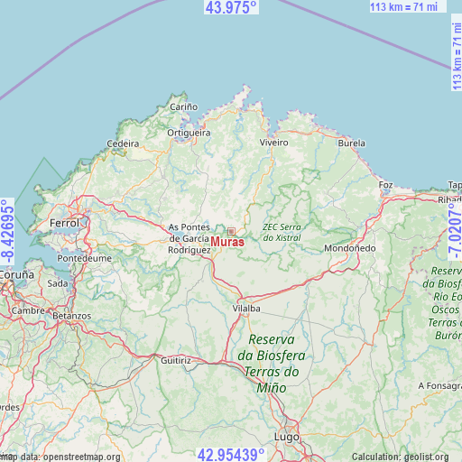
Muras GPS coordinates[2]
43° 28' 0.66" North, 7° 43' 25.788" West
| Map corner | latitude | longitude |
|---|---|---|
| Upper-left | 43.975°, | -8.42695° |
| Center: | 43.46685°, | -7.72383° |
| Lower-right: | 42.95439°, | -7.0207° |
| Map W x H: | 113.5×113.5 km | = 70.5×70.5mi |
| max Lat: | 43.74134° ⇑0.7% North |
| Muras: | 43.46685° |
| min Lat: | ⇓99.3% South 27.64134° |
| min Long | Muras | max Long |
| -18.00367° | -7.72383° | 4.2899° |
| W 4.2%⇐ | ⇒95.8% E |
Elevation
Elevation of Muras is 470 m = 1542 ft, and this is 128 m = 420 ft below average elevation for this country.
| Max E: |
1682 m = 5518 ft | 64.2% |
| Avg. | 598 m = 1962 ft | |
| Muras | 470 m = 1542 ft | |
Min E: |
0 m = 0 ft | 35.8% |
See also: Spain elevation on elevation.city.
Geographical zone
Muras is located in North temperate zone (between Tropic of Cancer and the Arctic Circle). Distance of this Northern Tropic circle is 2227.1 km =1383.9 mi to South.| Distance of | km | miles | from Muras |
|---|---|---|---|
| North Pole | 5174 | 3215 | to North |
| Arctic Circle | 2568.1 | 1595.7 | to North |
| Tropic Cancer | 2227.1 | 1383.9 | to South |
| Equator | 4833.1 | 3003.1 | to South |


Nearby cities:
15 places around Muras: (largest is in red/bold)
• Abadín
22.4 km =13.9 mi,  119°
119°
• As Pontes de García Rodríguez
10.4 km =6.5 mi,  261°
261°
• Cariño
32.6 km =20.3 mi,  339°
339°
• Cerdido
28 km =17.4 mi,  307°
307°
• Mañón
20.4 km =12.7 mi,  357°
357°
• Moeche
25.4 km =15.8 mi,  291°
291°
• Mondoñedo
27.2 km =16.9 mi,  105°
105°
• Mondoñedo
29.8 km =18.5 mi,  98°
98°
• Monfero
27.9 km =17.3 mi,  237°
237°
• San Sadurniño
28.6 km =17.8 mi,  284°
284°
• Santa Marta de Ortigueira
26.1 km =16.2 mi, 337°
• Somozas
18.4 km =11.4 mi, 293°
• Vilalba
19.1 km =11.9 mi,  169°
169°
• Viveiro
24.1 km =15 mi,  25°
25°
• Xove
29.8 km =18.5 mi,  35°
35°
Sources, notices
• [Note1] Compared only with cities in Spain existing in our database
• [Src1] Map data: © OpenStreetMap contributors (CC-BY-SA)
• [Src2] Other city data from geonames.org with taken over terms of usage.
• [Src3] Geographical zone / Annual Mean Temperature by Robert A. Rohde @ Wikipedia
