Trazo geodata
Trazo (Galicia) is a seat of a third-order administrative division; located in Spain in Europe/Madrid (GMT+2) time zone. With population of 3,592 people, there are 1564 cities with bigger population in this country. Compared to other cities in Spain, 94.5% of cities are located further ↓South; 97.4% of cities are located further →East and 74.4% of cities have higher elevation than Trazo. Note1


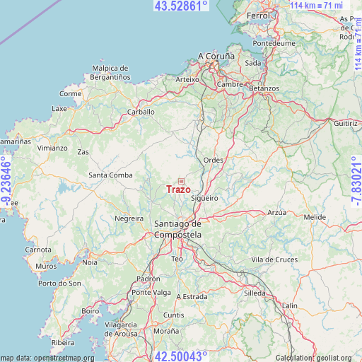
Trazo GPS coordinates[2]
43° 1' 0.012" North, 8° 31' 59.988" West
| Map corner | latitude | longitude |
|---|---|---|
| Upper-left | 43.52861°, | -9.23646° |
| Center: | 43.01667°, | -8.53333° |
| Lower-right: | 42.50043°, | -7.83021° |
| Map W x H: | 114.3×114.3 km | = 71×71mi |
| max Lat: | 43.74134° ⇑5.5% North |
| Trazo: | 43.01667° |
| min Lat: | ⇓94.5% South 27.64134° |
| min Long | Trazo | max Long |
| -18.00367° | -8.53333° | 4.2899° |
| W 2.6%⇐ | ⇒97.4% E |
Elevation
Elevation of Trazo is 307 m = 1007 ft, and this is 291 m = 955 ft below average elevation for this country.
| Max E: |
1682 m = 5518 ft | 74.4% |
| Avg. | 598 m = 1962 ft | |
| Trazo | 307 m = 1007 ft | |
Min E: |
0 m = 0 ft | 25.6% |
See also: Spain elevation on elevation.city.
Geographical zone
Trazo is located in North temperate zone (between Tropic of Cancer and the Arctic Circle). Distance of this Northern Tropic circle is 2177.1 km =1352.8 mi to South.| Distance of | km | miles | from Trazo |
|---|---|---|---|
| North Pole | 5224.1 | 3246.1 | to North |
| Arctic Circle | 2618.2 | 1626.9 | to North |
| Tropic Cancer | 2177.1 | 1352.8 | to South |
| Equator | 4783 | 2972 | to South |


Nearby cities:
15 places around Trazo: (largest is in red/bold)
• A Baña
19.3 km =12 mi,  251°
251°
• Amés
16 km =9.9 mi,  218°
218°
• Carballo
25.3 km =15.7 mi,  329°
329°
• Cerceda
19 km =11.8 mi,  12°
12°
• Frades
19.8 km =12.3 mi,  79°
79°
• Laracha
26.7 km =16.6 mi,  350°
350°
• Mesia
23.6 km =14.7 mi,  66°
66°
• Negreira
21.1 km =13.1 mi,  233°
233°
• Ordes
12.1 km =7.5 mi,  56°
56°
• Oroso
8.9 km =5.5 mi,  114°
114°
• San Roque
26.9 km =16.7 mi,  319°
319°
• Santa Comba
22.5 km =14 mi,  274°
274°
• Santiago de Compostela
15.2 km =9.4 mi,  183°
183°
• Touro
24.7 km =15.3 mi,  131°
131°
• Vedra
26.9 km =16.7 mi,  170°
170°
Sources, notices
• [Note1] Compared only with cities in Spain existing in our database
• [Src1] Map data: © OpenStreetMap contributors (CC-BY-SA)
• [Src2] Other city data from geonames.org with taken over terms of usage.
• [Src3] Geographical zone / Annual Mean Temperature by Robert A. Rohde @ Wikipedia
