Ordes geodata
Ordes (Galicia) is a populated place; located in Spain in Europe/Madrid (GMT+2) time zone. With population of 12,757 people, there are 717 cities with bigger population in this country. Compared to other cities in Spain, 95% of cities are located further ↓South; 97.1% of cities are located further →East and 76.6% of cities have higher elevation than Ordes. Note1


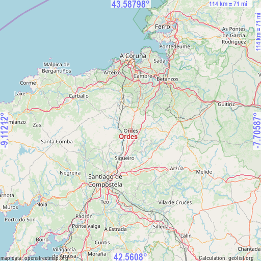
Ordes GPS coordinates[2]
43° 4' 35.544" North, 8° 24' 32.4" West
| Map corner | latitude | longitude |
|---|---|---|
| Upper-left | 43.58798°, | -9.11212° |
| Center: | 43.07654°, | -8.409° |
| Lower-right: | 42.5608°, | -7.70587° |
| Map W x H: | 114.2×114.2 km | = 71×71mi |
| max Lat: | 43.74134° ⇑5% North |
| Ordes: | 43.07654° |
| min Lat: | ⇓95% South 27.64134° |
| min Long | Ordes | max Long |
| -18.00367° | -8.409° | 4.2899° |
| W 2.9%⇐ | ⇒97.1% E |
Elevation
Elevation of Ordes is 277 m = 909 ft, and this is 321 m = 1053 ft below average elevation for this country.
| Max E: |
1682 m = 5518 ft | 76.6% |
| Avg. | 598 m = 1962 ft | |
| Ordes | 277 m = 909 ft | |
Min E: |
0 m = 0 ft | 23.4% |
See also: Spain elevation on elevation.city.
Geographical zone
Ordes is located in North temperate zone (between Tropic of Cancer and the Arctic Circle). Distance of this Northern Tropic circle is 2183.7 km =1356.9 mi to South.| Distance of | km | miles | from Ordes |
|---|---|---|---|
| North Pole | 5217.4 | 3241.9 | to North |
| Arctic Circle | 2611.5 | 1622.7 | to North |
| Tropic Cancer | 2183.7 | 1356.9 | to South |
| Equator | 4789.7 | 2976.2 | to South |


Nearby cities:
15 places around Ordes: (largest is in red/bold)
• Abegondo
18.6 km =11.6 mi,  33°
33°
• Boimorto
24 km =14.9 mi,  110°
110°
• Carral
17.5 km =10.9 mi,  14°
14°
• Cerceda
13.3 km =8.3 mi,  333°
333°
• Cesuras
20 km =12.4 mi,  57°
57°
• Culleredo
23.6 km =14.7 mi,  4°
4°
• Curtis
21.8 km =13.5 mi,  76°
76°
• Frades
9.8 km =6.1 mi, 107°
• Laracha
24.3 km =15.1 mi,  324°
324°
• Mesia
11.8 km =7.3 mi, 77°
• Oroso
10.6 km =6.6 mi,  190°
190°
• Santiago de Compostela
24.5 km =15.2 mi,  207°
207°
• Touro
24.6 km =15.3 mi,  160°
160°
• Trazo
12.1 km =7.5 mi,  236°
236°
• Vilasantar
23.3 km =14.5 mi,  91°
91°
Sources, notices
• [Note1] Compared only with cities in Spain existing in our database
• [Src1] Map data: © OpenStreetMap contributors (CC-BY-SA)
• [Src2] Other city data from geonames.org with taken over terms of usage.
• [Src3] Geographical zone / Annual Mean Temperature by Robert A. Rohde @ Wikipedia
