Cebrecos geodata
Cebrecos (Castille and León) is a seat of a third-order administrative division; located in Spain in Europe/Madrid (GMT+2) time zone. With population of 64 people, there are 6303 cities with bigger population in this country. Compared to other cities in Spain, 73.4% of cities are located further ↓South; 53.6% of cities are located further →East and 85.2% of cities have lower elevation than Cebrecos. Note1
Administrative division(s):
- Level 1: Castille and León
- Level 2: Provincia de Burgos
- Level 3: Cebrecos


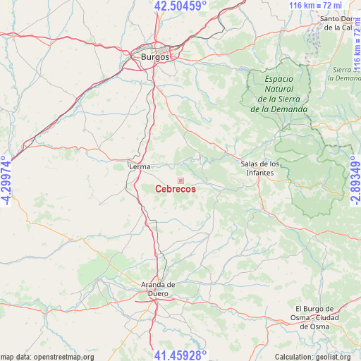
Cebrecos GPS coordinates[2]
41° 59' 2.688" North, 3° 35' 47.796" West
| Map corner | latitude | longitude |
|---|---|---|
| Upper-left | 42.50459°, | -4.29974° |
| Center: | 41.98408°, | -3.59661° |
| Lower-right: | 41.45928°, | -2.89349° |
| Map W x H: | 116.2×116.2 km | = 72.2×72.2mi |
| max Lat: | 43.74134° ⇑26.6% North |
| Cebrecos: | 41.98408° |
| min Lat: | ⇓73.4% South 27.64134° |
| min Long | Cebrecos | max Long |
| -18.00367° | -3.59661° | 4.2899° |
| W 46.4%⇐ | ⇒53.6% E |
Elevation
Elevation of Cebrecos is 953 m = 3127 ft, and this is 355 m = 1165 ft above average elevation for this country.
| Max E: |
1682 m = 5518 ft | 14.8% |
| Cebrecos | 953 m 3127 ft | |
| Avg. | 598 m = 1962 ft | |
Min E: |
0 m = 0 ft | 85.2% |
See also: Spain elevation on elevation.city.
Geographical zone
Cebrecos is located in North temperate zone (between Tropic of Cancer and the Arctic Circle). Distance of this Northern Tropic circle is 2062.3 km =1281.5 mi to South.| Distance of | km | miles | from Cebrecos |
|---|---|---|---|
| North Pole | 5338.9 | 3317.4 | to North |
| Arctic Circle | 2733 | 1698.2 | to North |
| Tropic Cancer | 2062.3 | 1281.5 | to South |
| Equator | 4668.2 | 2900.7 | to South |


Nearby cities:
15 places around Cebrecos: (largest is in red/bold)
• Cilleruelo de Arriba
10.3 km =6.4 mi,  211°
211°
• Ciruelos de Cervera
10.3 km =6.4 mi,  147°
147°
• Covarrubias
10.5 km =6.5 mi,  37°
37°
• Fontioso
12.6 km =7.8 mi,  248°
248°
• Mecerreyes
12.5 km =7.8 mi,  8°
8°
• Nebreda
3.5 km =2.2 mi,  241°
241°
• Puentedura
6.5 km =4 mi, 10°
• Quintanilla de la Mata
14.1 km =8.8 mi,  272°
272°
• Quintanilla del Coco
6.6 km =4.1 mi,  90°
90°
• Retuerta
9 km =5.6 mi,  55°
55°
• Santa Inés
10.8 km =6.7 mi,  305°
305°
• Santibáñez del Val
9.6 km =6 mi,  97°
97°
• Solarana
5.3 km =3.3 mi, 254°
• Tejada
6.2 km =3.9 mi,  124°
124°
• Villalmanzo
14 km =8.7 mi,  300°
300°
Sources, notices
• [Note1] Compared only with cities in Spain existing in our database
• [Src1] Map data: © OpenStreetMap contributors (CC-BY-SA)
• [Src2] Other city data from geonames.org with taken over terms of usage.
• [Src3] Geographical zone / Annual Mean Temperature by Robert A. Rohde @ Wikipedia
