Castellfollit de Riubregós geodata
Castellfollit de Riubregós (Catalonia) is a seat of a third-order administrative division; located in Spain in Europe/Madrid (GMT+2) time zone. In our database, there are 6762 cities with bigger population. Compared to other cities in Spain, 67.8% of cities are located further ↓South; 91.6% of cities are located further ←West and 58.5% of cities have higher elevation than Castellfollit de Riubregós. Note1
Administrative division(s):
- Level 1: Catalonia
- Level 2: Província de Barcelona
- Level 3: Castellfollit de Riubregós
Current local time in Castellfollit de Riubregós:
10:47 PM, ThursdayDifference from your time zone: hours


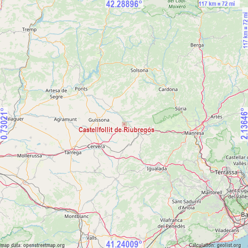
Castellfollit de Riubregós GPS coordinates[2]
41° 46' 0.012" North, 1° 25' 59.988" East
| Map corner | latitude | longitude |
|---|---|---|
| Upper-left | 42.28896°, | 0.73021° |
| Center: | 41.76667°, | 1.43333° |
| Lower-right: | 41.24009°, | 2.13646° |
| Map W x H: | 116.6×116.6 km | = 72.5×72.5mi |
| max Lat: | 43.74134° ⇑32.2% North |
| Castellfollit de Riubregós: | 41.76667° |
| min Lat: | ⇓67.8% South 27.64134° |
| min Long | Castellfollit d | max Long |
| -18.00367° | 1.43333° | 4.2899° |
| W 91.6%⇐ | ⇒8.4% E |
Elevation
Elevation of Castellfollit de Riubregós is 548 m = 1798 ft, and this is 50 m = 164 ft below average elevation for this country.
| Max E: |
1682 m = 5518 ft | 58.5% |
| Avg. | 598 m = 1962 ft | |
| Castellfollit de Riubregós | 548 m = 1798 ft | |
Min E: |
0 m = 0 ft | 41.5% |
See also: Spain elevation on elevation.city.
Geographical zone
Castellfollit de Riubregós is located in North temperate zone (between Tropic of Cancer and the Arctic Circle). Distance of this Northern Tropic circle is 2038.1 km =1266.4 mi to South.| Distance of | km | miles | from Castellfollit de Riubregós |
|---|---|---|---|
| North Pole | 5363 | 3332.4 | to North |
| Arctic Circle | 2757.2 | 1713.2 | to North |
| Tropic Cancer | 2038.1 | 1266.4 | to South |
| Equator | 4644 | 2885.6 | to South |


Nearby cities:
15 places around Castellfollit de Riubregós: (largest is in red/bold)
• Aguilar de Segarra
16.4 km =10.2 mi,  97°
97°
• Argensola
18.8 km =11.7 mi,  177°
177°
• Calaf
7.7 km =4.8 mi,  119°
119°
• Castellfollit del Boix
24.8 km =15.4 mi, 116°
• Cervera
17.2 km =10.7 mi,  231°
231°
• Fonollosa
19.5 km =12.1 mi,  91°
91°
• Igualada
25.7 km =16 mi,  143°
143°
• Ivorra
2.8 km =1.7 mi,  270°
270°
• Jorba
20.6 km =12.8 mi,  152°
152°
• Ossó de Sió
22.8 km =14.2 mi, 266°
• Pujalt
5.6 km =3.5 mi,  190°
190°
• Rajadell
23 km =14.3 mi, 100°
• Sant Guim de Freixenet
12.4 km =7.7 mi, 185°
• Sant Martí de Tous
25.1 km =15.6 mi,  163°
163°
• Torà de Riubregós
6.2 km =3.9 mi,  333°
333°
Sources, notices
• [Note1] Compared only with cities in Spain existing in our database
• [Src1] Map data: © OpenStreetMap contributors (CC-BY-SA)
• [Src2] Other city data from geonames.org with taken over terms of usage.
• [Src3] Geographical zone / Annual Mean Temperature by Robert A. Rohde @ Wikipedia
