Calaf geodata
Calaf (Catalonia) is a seat of a third-order administrative division; located in Spain in Europe/Madrid (GMT+2) time zone. With population of 3,306 people, there are 1633 cities with bigger population in this country. Compared to other cities in Spain, 66.8% of cities are located further ↓South; 91.8% of cities are located further ←West and 52% of cities have lower elevation than Calaf. Note1


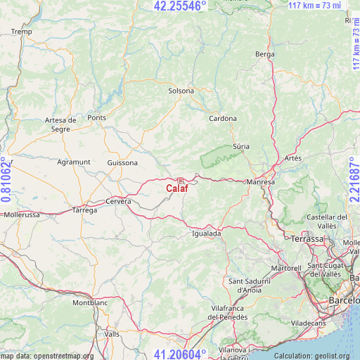
Calaf GPS coordinates[2]
41° 43' 58.404" North, 1° 30' 49.5" East
| Map corner | latitude | longitude |
|---|---|---|
| Upper-left | 42.25546°, | 0.81062° |
| Center: | 41.73289°, | 1.51375° |
| Lower-right: | 41.20604°, | 2.21687° |
| Map W x H: | 116.7×116.7 km | = 72.5×72.5mi |
| max Lat: | 43.74134° ⇑33.2% North |
| Calaf: | 41.73289° |
| min Lat: | ⇓66.8% South 27.64134° |
| min Long | Calaf | max Long |
| -18.00367° | 1.51375° | 4.2899° |
| W 91.8%⇐ | ⇒8.2% E |
Elevation
Elevation of Calaf is 680 m = 2231 ft, and this is 82 m = 269 ft above average elevation for this country.
| Max E: |
1682 m = 5518 ft | 48% |
| Calaf | 680 m 2231 ft | |
| Avg. | 598 m = 1962 ft | |
Min E: |
0 m = 0 ft | 52% |
See also: Spain elevation on elevation.city.
Geographical zone
Calaf is located in North temperate zone (between Tropic of Cancer and the Arctic Circle). Distance of this Northern Tropic circle is 2034.3 km =1264.1 mi to South.| Distance of | km | miles | from Calaf |
|---|---|---|---|
| North Pole | 5366.8 | 3334.8 | to North |
| Arctic Circle | 2760.9 | 1715.5 | to North |
| Tropic Cancer | 2034.3 | 1264.1 | to South |
| Equator | 4640.3 | 2883.3 | to South |


Nearby cities:
15 places around Calaf: (largest is in red/bold)
• Aguilar de Segarra
9.7 km =6 mi,  79°
79°
• Argensola
16 km =9.9 mi,  200°
200°
• Castellfollit de Riubregós
7.7 km =4.8 mi,  299°
299°
• Castellfollit del Boix
17.1 km =10.6 mi,  115°
115°
• Fonollosa
13.3 km =8.3 mi, 75°
• Igualada
19 km =11.8 mi,  153°
153°
• Ivorra
10.2 km =6.3 mi,  291°
291°
• Jorba
14.8 km =9.2 mi,  169°
169°
• Pujalt
7.9 km =4.9 mi,  257°
257°
• Rajadell
16 km =9.9 mi,  91°
91°
• Sant Guim de Freixenet
11.6 km =7.2 mi,  222°
222°
• Sant Martí de Tous
20.3 km =12.6 mi,  179°
179°
• Torà de Riubregós
13.3 km =8.3 mi,  314°
314°
• Vilanova del Camí
20.7 km =12.9 mi, 150°
• Òdena
18.6 km =11.6 mi,  142°
142°
Sources, notices
• [Note1] Compared only with cities in Spain existing in our database
• [Src1] Map data: © OpenStreetMap contributors (CC-BY-SA)
• [Src2] Other city data from geonames.org with taken over terms of usage.
• [Src3] Geographical zone / Annual Mean Temperature by Robert A. Rohde @ Wikipedia
