Castellolí geodata
Castellolí (Catalonia) is a seat of a third-order administrative division; located in Spain in Europe/Madrid (GMT+2) time zone. With population of 461 people, there are 3981 cities with bigger population in this country. Compared to other cities in Spain, 63.4% of cities are located further ↓South; 92.3% of cities are located further ←West and 69.4% of cities have higher elevation than Castellolí. Note1


Castellolí GPS coordinates[2]
41° 35' 53.844" North, 1° 42' 2.052" East
| Map corner | latitude | longitude |
|---|---|---|
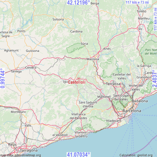
| Upper-left | 42.12196°, | 0.99744° |
| Center: | 41.59829°, | 1.70057° |
| Lower-right: | 41.07034°, | 2.4037° |
| Map W x H: | 116.9×116.9 km | = 72.6×72.6mi |
| max Lat: | 43.74134° ⇑36.6% North |
| Castellolí: | 41.59829° |
| min Lat: | ⇓63.4% South 27.64134° |
| min Long | Castellolí | max Long |
| -18.00367° | 1.70057° | 4.2899° |
| W 92.3%⇐ | ⇒7.7% E |
Elevation
Elevation of Castellolí is 393 m = 1289 ft, and this is 205 m = 673 ft below average elevation for this country.
| Max E: |
1682 m = 5518 ft | 69.4% |
| Avg. | 598 m = 1962 ft | |
| Castellolí | 393 m = 1289 ft | |
Min E: |
0 m = 0 ft | 30.6% |
See also: Spain elevation on elevation.city.
Geographical zone
Castellolí is located in North temperate zone (between Tropic of Cancer and the Arctic Circle). Distance of this Northern Tropic circle is 2019.4 km =1254.8 mi to South.| Distance of | km | miles | from Castellolí |
|---|---|---|---|
| North Pole | 5381.8 | 3344.1 | to North |
| Arctic Circle | 2775.9 | 1724.9 | to North |
| Tropic Cancer | 2019.4 | 1254.8 | to South |
| Equator | 4625.3 | 2874 | to South |


Nearby cities:
15 places around Castellolí: (largest is in red/bold)
• Capellades
7.7 km =4.8 mi,  188°
188°
• Carme
9.9 km =6.2 mi,  222°
222°
• Castellfollit del Boix
7.6 km =4.7 mi,  359°
359°
• Collbató
11 km =6.8 mi,  106°
106°
• Igualada
7.2 km =4.5 mi,  254°
254°
• Jorba
12.7 km =7.9 mi,  271°
271°
• La Pobla de Claramunt
5.3 km =3.3 mi,  201°
201°
• Masquefa
14 km =8.7 mi,  138°
138°
• Monistrol de Montserrat
12.6 km =7.8 mi,  80°
80°
• Orpí
13.7 km =8.5 mi,  229°
229°
• Piera
9.4 km =5.8 mi,  153°
153°
• Rajadell
14.4 km =8.9 mi,  1°
1°
• Sant Salvador de Guardiola
10.9 km =6.8 mi,  30°
30°
• Vilanova del Camí
6 km =3.7 mi,  240°
240°
• Òdena
4.2 km =2.6 mi, 272°
Sources, notices
• [Note1] Compared only with cities in Spain existing in our database
• [Src1] Map data: © OpenStreetMap contributors (CC-BY-SA)
• [Src2] Other city data from geonames.org with taken over terms of usage.
• [Src3] Geographical zone / Annual Mean Temperature by Robert A. Rohde @ Wikipedia
