Castejón geodata
Castejón (Navarre) is a populated place; located in Spain in Europe/Madrid (GMT+2) time zone. With population of 3,615 people, there are 1560 cities with bigger population in this country. Compared to other cities in Spain, 78.5% of cities are located further ↓South; 70.8% of cities are located further ←West and 76.5% of cities have higher elevation than Castejón. Note1


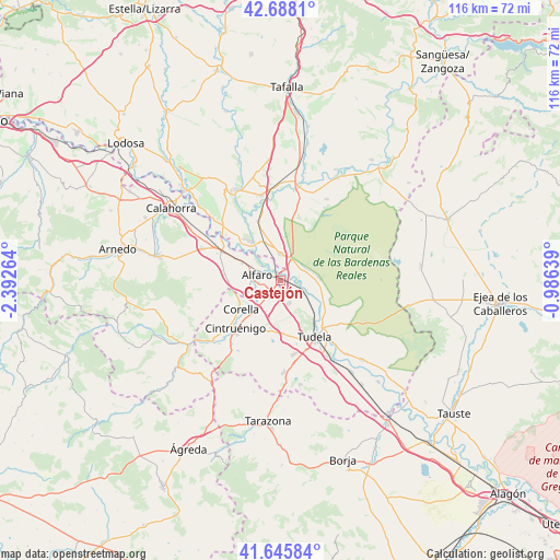
Castejón GPS coordinates[2]
42° 10' 8.832" North, 1° 41' 22.236" West
| Map corner | latitude | longitude |
|---|---|---|
| Upper-left | 42.6881°, | -2.39264° |
| Center: | 42.16912°, | -1.68951° |
| Lower-right: | 41.64584°, | -0.98639° |
| Map W x H: | 115.9×115.9 km | = 72×72mi |
| max Lat: | 43.74134° ⇑21.5% North |
| Castejón: | 42.16912° |
| min Lat: | ⇓78.5% South 27.64134° |
| min Long | Castejón | max Long |
| -18.00367° | -1.68951° | 4.2899° |
| W 70.8%⇐ | ⇒29.2% E |
Elevation
Elevation of Castejón is 278 m = 912 ft, and this is 320 m = 1050 ft below average elevation for this country.
| Max E: |
1682 m = 5518 ft | 76.5% |
| Avg. | 598 m = 1962 ft | |
| Castejón | 278 m = 912 ft | |
Min E: |
0 m = 0 ft | 23.5% |
See also: Spain elevation on elevation.city.
Geographical zone
Castejón is located in North temperate zone (between Tropic of Cancer and the Arctic Circle). Distance of this Northern Tropic circle is 2082.8 km =1294.2 mi to South.| Distance of | km | miles | from Castejón |
|---|---|---|---|
| North Pole | 5318.3 | 3304.6 | to North |
| Arctic Circle | 2712.4 | 1685.4 | to North |
| Tropic Cancer | 2082.8 | 1294.2 | to South |
| Equator | 4688.8 | 2913.5 | to South |


Nearby cities:
15 places around Castejón: (largest is in red/bold)
• Aldeanueva de Ebro
17.6 km =10.9 mi,  292°
292°
• Alfaro
5.2 km =3.2 mi,  283°
283°
• Arguedas
7.7 km =4.8 mi,  82°
82°
• Cadreita
5.3 km =3.3 mi,  5°
5°
• Cintruénigo
13.8 km =8.6 mi,  223°
223°
• Corella
9.9 km =6.2 mi,  232°
232°
• Fitero
18.6 km =11.6 mi, 228°
• Fontellas
18.4 km =11.4 mi,  149°
149°
• Marcilla
18.1 km =11.2 mi,  347°
347°
• Milagro
10.2 km =6.3 mi,  322°
322°
• Murchante
15.5 km =9.6 mi,  169°
169°
• Rincón de Soto
15.3 km =9.5 mi,  298°
298°
• Tudela
13.9 km =8.6 mi, 149°
• Valtierra
5.5 km =3.4 mi,  56°
56°
• Villafranca
13.1 km =8.1 mi,  339°
339°
Sources, notices
• [Note1] Compared only with cities in Spain existing in our database
• [Src1] Map data: © OpenStreetMap contributors (CC-BY-SA)
• [Src2] Other city data from geonames.org with taken over terms of usage.
• [Src3] Geographical zone / Annual Mean Temperature by Robert A. Rohde @ Wikipedia
