Alfaro geodata
Alfaro (La Rioja) is a seat of a third-order administrative division; located in Spain in Europe/Madrid (GMT+2) time zone. With population of 9,574 people, there are 872 cities with bigger population in this country. Compared to other cities in Spain, 78.8% of cities are located further ↓South; 70% of cities are located further ←West and 74.8% of cities have higher elevation than Alfaro. Note1


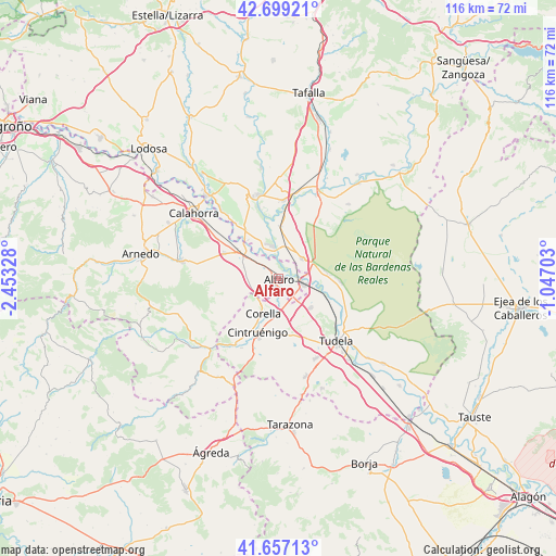
Alfaro GPS coordinates[2]
42° 10' 49.152" North, 1° 45' 0.576" West
| Map corner | latitude | longitude |
|---|---|---|
| Upper-left | 42.69921°, | -2.45328° |
| Center: | 42.18032°, | -1.75016° |
| Lower-right: | 41.65713°, | -1.04703° |
| Map W x H: | 115.9×115.9 km | = 72×72mi |
| max Lat: | 43.74134° ⇑21.2% North |
| Alfaro: | 42.18032° |
| min Lat: | ⇓78.8% South 27.64134° |
| min Long | Alfaro | max Long |
| -18.00367° | -1.75016° | 4.2899° |
| W 70%⇐ | ⇒30% E |
Elevation
Elevation of Alfaro is 298 m = 978 ft, and this is 300 m = 984 ft below average elevation for this country.
| Max E: |
1682 m = 5518 ft | 74.8% |
| Avg. | 598 m = 1962 ft | |
| Alfaro | 298 m = 978 ft | |
Min E: |
0 m = 0 ft | 25.2% |
See also: Spain elevation on elevation.city.
Geographical zone
Alfaro is located in North temperate zone (between Tropic of Cancer and the Arctic Circle). Distance of this Northern Tropic circle is 2084.1 km =1295 mi to South.| Distance of | km | miles | from Alfaro |
|---|---|---|---|
| North Pole | 5317 | 3303.8 | to North |
| Arctic Circle | 2711.2 | 1684.7 | to North |
| Tropic Cancer | 2084.1 | 1295 | to South |
| Equator | 4690 | 2914.2 | to South |


Nearby cities:
15 places around Alfaro: (largest is in red/bold)
• Aldeanueva de Ebro
12.5 km =7.8 mi,  295°
295°
• Arguedas
12.6 km =7.8 mi,  91°
91°
• Cadreita
6.8 km =4.2 mi,  53°
53°
• Castejón
5.2 km =3.2 mi,  103°
103°
• Cintruénigo
12.1 km =7.5 mi,  201°
201°
• Corella
7.8 km =4.8 mi, 201°
• Fitero
16.3 km =10.1 mi,  213°
213°
• Funes
15.6 km =9.7 mi,  344°
344°
• Marcilla
16.4 km =10.2 mi,  3°
3°
• Milagro
6.9 km =4.3 mi,  349°
349°
• Peralta
18 km =11.2 mi, 346°
• Rincón de Soto
10.4 km =6.5 mi,  305°
305°
• Tudela
17.8 km =11.1 mi,  137°
137°
• Valtierra
9.7 km =6 mi,  79°
79°
• Villafranca
11 km =6.8 mi, 1°
Sources, notices
• [Note1] Compared only with cities in Spain existing in our database
• [Src1] Map data: © OpenStreetMap contributors (CC-BY-SA)
• [Src2] Other city data from geonames.org with taken over terms of usage.
• [Src3] Geographical zone / Annual Mean Temperature by Robert A. Rohde @ Wikipedia
