Corella geodata
Corella (Navarre) is a seat of a third-order administrative division; located in Spain in Europe/Madrid (GMT+2) time zone. With population of 7,576 people, there are 973 cities with bigger population in this country. Compared to other cities in Spain, 76.8% of cities are located further ↓South; 69.7% of cities are located further ←West and 70% of cities have higher elevation than Corella. Note1


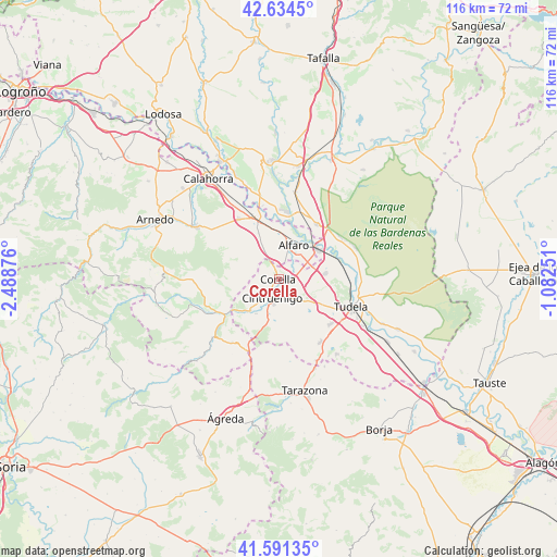
Corella GPS coordinates[2]
42° 6' 54.252" North, 1° 47' 8.268" West
| Map corner | latitude | longitude |
|---|---|---|
| Upper-left | 42.6345°, | -2.48876° |
| Center: | 42.11507°, | -1.78563° |
| Lower-right: | 41.59135°, | -1.08251° |
| Map W x H: | 116×116 km | = 72.1×72.1mi |
| max Lat: | 43.74134° ⇑23.2% North |
| Corella: | 42.11507° |
| min Lat: | ⇓76.8% South 27.64134° |
| min Long | Corella | max Long |
| -18.00367° | -1.78563° | 4.2899° |
| W 69.7%⇐ | ⇒30.3% E |
Elevation
Elevation of Corella is 380 m = 1247 ft, and this is 218 m = 715 ft below average elevation for this country.
| Max E: |
1682 m = 5518 ft | 70% |
| Avg. | 598 m = 1962 ft | |
| Corella | 380 m = 1247 ft | |
Min E: |
0 m = 0 ft | 30% |
See also: Spain elevation on elevation.city.
Geographical zone
Corella is located in North temperate zone (between Tropic of Cancer and the Arctic Circle). Distance of this Northern Tropic circle is 2076.8 km =1290.5 mi to South.| Distance of | km | miles | from Corella |
|---|---|---|---|
| North Pole | 5324.3 | 3308.4 | to North |
| Arctic Circle | 2718.4 | 1689.1 | to North |
| Tropic Cancer | 2076.8 | 1290.5 | to South |
| Equator | 4682.8 | 2909.8 | to South |


Nearby cities:
15 places around Corella: (largest is in red/bold)
• Aldeanueva de Ebro
15.2 km =9.4 mi,  326°
326°
• Alfaro
7.8 km =4.8 mi,  21°
21°
• Arguedas
17 km =10.6 mi,  65°
65°
• Cadreita
14.1 km =8.8 mi,  36°
36°
• Cascante
15.7 km =9.8 mi,  146°
146°
• Castejón
9.9 km =6.2 mi,  52°
52°
• Cintruénigo
4.3 km =2.7 mi,  201°
201°
• Fitero
8.7 km =5.4 mi,  222°
222°
• Grávalos
17.6 km =10.9 mi,  267°
267°
• Milagro
14.2 km =8.8 mi,  6°
6°
• Murchante
14.2 km =8.8 mi,  130°
130°
• Rincón de Soto
14.4 km =8.9 mi,  337°
337°
• Tudela
16.1 km =10 mi,  111°
111°
• Tulebras
17.8 km =11.1 mi, 149°
• Valtierra
15.4 km =9.6 mi, 53°
Sources, notices
• [Note1] Compared only with cities in Spain existing in our database
• [Src1] Map data: © OpenStreetMap contributors (CC-BY-SA)
• [Src2] Other city data from geonames.org with taken over terms of usage.
• [Src3] Geographical zone / Annual Mean Temperature by Robert A. Rohde @ Wikipedia
