Cintruénigo geodata
Cintruénigo (Navarre) is a seat of a third-order administrative division; located in Spain in Europe/Madrid (GMT+2) time zone. With population of 6,708 people, there are 1068 cities with bigger population in this country. Compared to other cities in Spain, 75.9% of cities are located further ↓South; 69.4% of cities are located further ←West and 68.9% of cities have higher elevation than Cintruénigo. Note1


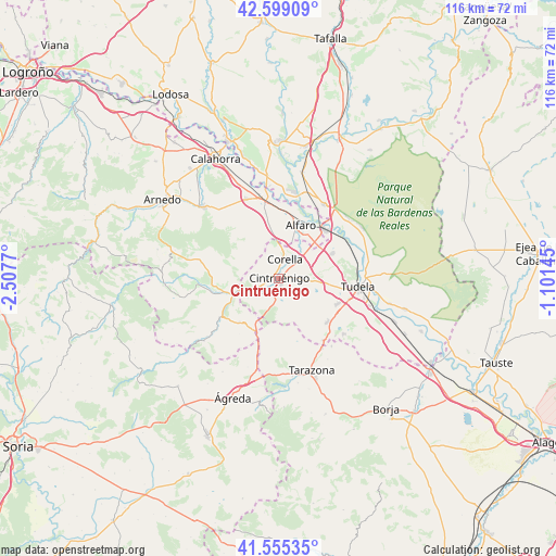
Cintruénigo GPS coordinates[2]
42° 4' 45.732" North, 1° 48' 16.488" West
| Map corner | latitude | longitude |
|---|---|---|
| Upper-left | 42.59909°, | -2.5077° |
| Center: | 42.07937°, | -1.80458° |
| Lower-right: | 41.55535°, | -1.10145° |
| Map W x H: | 116.1×116.1 km | = 72.1×72.1mi |
| max Lat: | 43.74134° ⇑24.1% North |
| Cintruénigo: | 42.07937° |
| min Lat: | ⇓75.9% South 27.64134° |
| min Long | Cintruénigo | max Long |
| -18.00367° | -1.80458° | 4.2899° |
| W 69.4%⇐ | ⇒30.6% E |
Elevation
Elevation of Cintruénigo is 400 m = 1312 ft, and this is 198 m = 650 ft below average elevation for this country.
| Max E: |
1682 m = 5518 ft | 68.9% |
| Avg. | 598 m = 1962 ft | |
| Cintruénigo | 400 m = 1312 ft | |
Min E: |
0 m = 0 ft | 31.1% |
See also: Spain elevation on elevation.city.
Geographical zone
Cintruénigo is located in North temperate zone (between Tropic of Cancer and the Arctic Circle). Distance of this Northern Tropic circle is 2072.9 km =1288 mi to South.| Distance of | km | miles | from Cintruénigo |
|---|---|---|---|
| North Pole | 5328.3 | 3310.9 | to North |
| Arctic Circle | 2722.4 | 1691.6 | to North |
| Tropic Cancer | 2072.9 | 1288 | to South |
| Equator | 4678.8 | 2907.3 | to South |


Nearby cities:
15 places around Cintruénigo: (largest is in red/bold)
• Ablitas
17.9 km =11.1 mi,  130°
130°
• Alfaro
12.1 km =7.5 mi,  21°
21°
• Cascante
13.7 km =8.5 mi, 131°
• Castejón
13.8 km =8.6 mi,  43°
43°
• Cervera del Río Alhama
14.9 km =9.3 mi,  236°
236°
• Corella
4.3 km =2.7 mi, 21°
• Fitero
5 km =3.1 mi, 241°
• Grávalos
16.3 km =10.1 mi,  281°
281°
• Igea
17.1 km =10.6 mi,  265°
265°
• Monteagudo
16 km =9.9 mi,  141°
141°
• Murchante
13.4 km =8.3 mi,  113°
113°
• Novallas
16.8 km =10.4 mi,  149°
149°
• Rincón de Soto
17.7 km =11 mi,  347°
347°
• Tudela
16.6 km =10.3 mi,  96°
96°
• Tulebras
15.6 km =9.7 mi, 137°
Sources, notices
• [Note1] Compared only with cities in Spain existing in our database
• [Src1] Map data: © OpenStreetMap contributors (CC-BY-SA)
• [Src2] Other city data from geonames.org with taken over terms of usage.
• [Src3] Geographical zone / Annual Mean Temperature by Robert A. Rohde @ Wikipedia
