Toén geodata
Toén (Galicia) is a seat of a third-order administrative division; located in Spain in Europe/Madrid (GMT+2) time zone. With population of 2,611 people, there are 1859 cities with bigger population in this country. Compared to other cities in Spain, 82.2% of cities are located further ↓South; 96.2% of cities are located further →East and 70.9% of cities have higher elevation than Toén. Note1


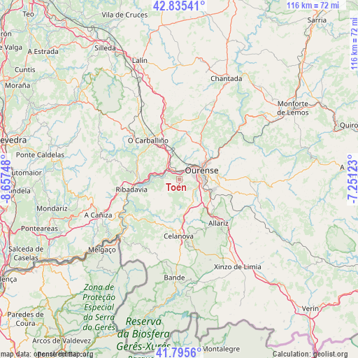
Toén GPS coordinates[2]
42° 19' 3.54" North, 7° 57' 15.66" West
| Map corner | latitude | longitude |
|---|---|---|
| Upper-left | 42.83541°, | -8.65748° |
| Center: | 42.31765°, | -7.95435° |
| Lower-right: | 41.7956°, | -7.25123° |
| Map W x H: | 115.6×115.6 km | = 71.8×71.8mi |
| max Lat: | 43.74134° ⇑17.8% North |
| Toén: | 42.31765° |
| min Lat: | ⇓82.2% South 27.64134° |
| min Long | Toén | max Long |
| -18.00367° | -7.95435° | 4.2899° |
| W 3.8%⇐ | ⇒96.2% E |
Elevation
Elevation of Toén is 369 m = 1211 ft, and this is 229 m = 751 ft below average elevation for this country.
| Max E: |
1682 m = 5518 ft | 70.9% |
| Avg. | 598 m = 1962 ft | |
| Toén | 369 m = 1211 ft | |
Min E: |
0 m = 0 ft | 29.1% |
See also: Spain elevation on elevation.city.
Geographical zone
Toén is located in North temperate zone (between Tropic of Cancer and the Arctic Circle). Distance of this Northern Tropic circle is 2099.4 km =1304.5 mi to South.| Distance of | km | miles | from Toén |
|---|---|---|---|
| North Pole | 5301.8 | 3294.4 | to North |
| Arctic Circle | 2695.9 | 1675.2 | to North |
| Tropic Cancer | 2099.4 | 1304.5 | to South |
| Equator | 4705.3 | 2923.7 | to South |


Nearby cities:
15 places around Toén: (largest is in red/bold)
• Amoeiro
11 km =6.8 mi,  1°
1°
• Beade
14.5 km =9 mi,  275°
275°
• Cartelle
12.1 km =7.5 mi,  232°
232°
• Castrelo de Miño
9.5 km =5.9 mi,  256°
256°
• Cenlle
11.5 km =7.1 mi, 283°
• Coles
13.5 km =8.4 mi,  47°
47°
• Maside
11.9 km =7.4 mi,  330°
330°
• O Carballiño
16.3 km =10.1 mi,  321°
321°
• Ourense
7.7 km =4.8 mi,  74°
74°
• Pereiro de Aguiar
13 km =8.1 mi,  76°
76°
• Punxín
7.5 km =4.7 mi, 321°
• Ribadavia
15.9 km =9.9 mi, 258°
• San Amaro
11.6 km =7.2 mi,  302°
302°
• Taboadela
13.4 km =8.3 mi,  128°
128°
• Vilarnaz
11.9 km =7.4 mi,  39°
39°
Sources, notices
• [Note1] Compared only with cities in Spain existing in our database
• [Src1] Map data: © OpenStreetMap contributors (CC-BY-SA)
• [Src2] Other city data from geonames.org with taken over terms of usage.
• [Src3] Geographical zone / Annual Mean Temperature by Robert A. Rohde @ Wikipedia
