Cariño geodata
Cariño (Galicia) is a seat of a third-order administrative division; located in Spain in Europe/Madrid (GMT+2) time zone. With population of 4,779 people, there are 1348 cities with bigger population in this country. Compared to other cities in Spain, 100% of cities are located further ↓South; 96.1% of cities are located further →East and 95.6% of cities have higher elevation than Cariño. Note1


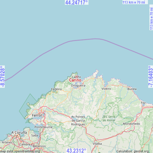
Cariño GPS coordinates[2]
43° 44' 28.824" North, 7° 52' 1.74" West
| Map corner | latitude | longitude |
|---|---|---|
| Upper-left | 44.24717°, | -8.57028° |
| Center: | 43.74134°, | -7.86715° |
| Lower-right: | 43.2312°, | -7.16403° |
| Map W x H: | 113×113 km | = 70.2×70.2mi |
| max Lat: | 43.74134° ⇑0% North |
| Cariño: | 43.74134° |
| min Lat: | ⇓100% South 27.64134° |
| min Long | Cariño | max Long |
| -18.00367° | -7.86715° | 4.2899° |
| W 3.9%⇐ | ⇒96.1% E |
Elevation
Elevation of Cariño is 22 m = 72 ft, and this is 576 m = 1890 ft below average elevation for this country.
| Max E: |
1682 m = 5518 ft | 95.6% |
| Avg. | 598 m = 1962 ft | |
| Cariño | 22 m = 72 ft | |
Min E: |
0 m = 0 ft | 4.4% |
See also: Spain elevation on elevation.city.
Geographical zone
Cariño is located in North temperate zone (between Tropic of Cancer and the Arctic Circle). Distance of this Northern Tropic circle is 2257.7 km =1402.9 mi to South.| Distance of | km | miles | from Cariño |
|---|---|---|---|
| North Pole | 5143.5 | 3196 | to North |
| Arctic Circle | 2537.6 | 1576.8 | to North |
| Tropic Cancer | 2257.7 | 1402.9 | to South |
| Equator | 4863.6 | 3022.1 | to South |


Nearby cities:
15 places around Cariño: (largest is in red/bold)
• As Pontes de García Rodríguez
32.1 km =19.9 mi,  177°
177°
• Burela de Cabo
38.9 km =24.2 mi,  105°
105°
• Cedeira
17.7 km =11 mi,  239°
239°
• Cerdido
17.1 km =10.6 mi,  218°
218°
• Cervo
37.6 km =23.4 mi,  102°
102°
• Mañón
14.8 km =9.2 mi,  133°
133°
• Moeche
24.4 km =15.2 mi,  209°
209°
• Muras
32.6 km =20.3 mi,  159°
159°
• Narón
37.3 km =23.2 mi, 224°
• San Sadurniño
28.2 km =17.5 mi, 214°
• Santa Marta de Ortigueira
6.6 km =4.1 mi,  167°
167°
• Somozas
23.7 km =14.7 mi,  192°
192°
• Valdoviño
26.6 km =16.5 mi,  233°
233°
• Viveiro
23.7 km =14.7 mi, 111°
• Xove
29.2 km =18.1 mi, 102°
Sources, notices
• [Note1] Compared only with cities in Spain existing in our database
• [Src1] Map data: © OpenStreetMap contributors (CC-BY-SA)
• [Src2] Other city data from geonames.org with taken over terms of usage.
• [Src3] Geographical zone / Annual Mean Temperature by Robert A. Rohde @ Wikipedia
