Salsadella geodata
Salsadella (Valencia) is a populated place; located in Spain in Europe/Madrid (GMT+2) time zone. With population of 810 people, there are 3190 cities with bigger population in this country. Compared to other cities in Spain, 63.6% of cities are located further ↑North; 87.9% of cities are located further ←West and 72.1% of cities have higher elevation than Salsadella. Note1


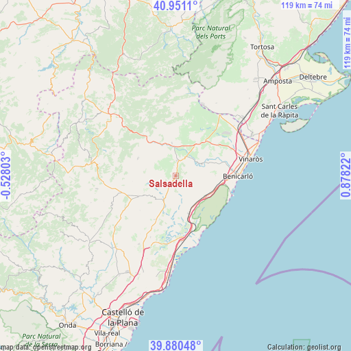
Salsadella GPS coordinates[2]
40° 25' 4.512" North, 0° 10' 30.324" East
| Map corner | latitude | longitude |
|---|---|---|
| Upper-left | 40.9511°, | -0.52803° |
| Center: | 40.41792°, | 0.17509° |
| Lower-right: | 39.88048°, | 0.87822° |
| Map W x H: | 119×119 km | = 73.9×73.9mi |
| max Lat: | 43.74134° ⇑63.6% North |
| Salsadella: | 40.41792° |
| min Lat: | ⇓36.4% South 27.64134° |
| min Long | Salsadella | max Long |
| -18.00367° | 0.17509° | 4.2899° |
| W 87.9%⇐ | ⇒12.1% E |
Elevation
Elevation of Salsadella is 345 m = 1132 ft, and this is 253 m = 830 ft below average elevation for this country.
| Max E: |
1682 m = 5518 ft | 72.1% |
| Avg. | 598 m = 1962 ft | |
| Salsadella | 345 m = 1132 ft | |
Min E: |
0 m = 0 ft | 27.9% |
See also: Spain elevation on elevation.city.
Geographical zone
Salsadella is located in North temperate zone (between Tropic of Cancer and the Arctic Circle). Distance of this Northern Tropic circle is 1888.1 km =1173.2 mi to South.| Distance of | km | miles | from Salsadella |
|---|---|---|---|
| North Pole | 5513 | 3425.6 | to North |
| Arctic Circle | 2907.1 | 1806.4 | to North |
| Tropic Cancer | 1888.1 | 1173.2 | to South |
| Equator | 4494.1 | 2792.5 | to South |


Nearby cities:
15 places around Salsadella: (largest is in red/bold)
• Albocàsser
14.2 km =8.8 mi,  237°
237°
• Alcalà de Xivert
14 km =8.7 mi,  159°
159°
• Alcocéber
20.7 km =12.9 mi,  153°
153°
• Canet lo Roig
15.9 km =9.9 mi,  21°
21°
• Catí
14.2 km =8.8 mi,  294°
294°
• Cervera del Maestre
9.5 km =5.9 mi,  65°
65°
• Chert/Xert
11.4 km =7.1 mi,  352°
352°
• Cuevas de Vinromá
12.9 km =8 mi,  200°
200°
• Càlig
16 km =9.9 mi, 71°
• Peníscola
20.8 km =12.9 mi,  108°
108°
• Sant Jordi
16.8 km =10.4 mi,  52°
52°
• Santa Magdalena de Pulpis
12.8 km =8 mi,  122°
122°
• Sarratella
16.9 km =10.5 mi,  226°
226°
• Tirig
8.2 km =5.1 mi,  274°
274°
• Traiguera
15.4 km =9.6 mi,  39°
39°
Sources, notices
• [Note1] Compared only with cities in Spain existing in our database
• [Src1] Map data: © OpenStreetMap contributors (CC-BY-SA)
• [Src2] Other city data from geonames.org with taken over terms of usage.
• [Src3] Geographical zone / Annual Mean Temperature by Robert A. Rohde @ Wikipedia
