Chert/Xert geodata
Chert/Xert (Valencia) is a seat of a third-order administrative division; located in Spain in Europe/Madrid (GMT+2) time zone. With population of 890 people, there are 3077 cities with bigger population in this country. Compared to other cities in Spain, 61.4% of cities are located further ↑North; 87.8% of cities are located further ←West and 65.3% of cities have higher elevation than Chert/Xert. Note1


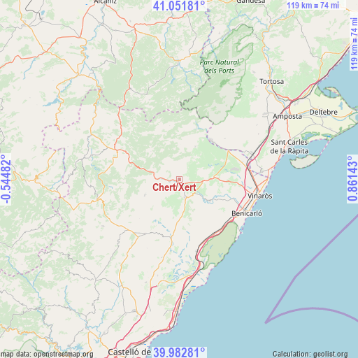
Chert/Xert GPS coordinates[2]
40° 31' 9.984" North, 0° 9' 29.916" East
| Map corner | latitude | longitude |
|---|---|---|
| Upper-left | 41.05181°, | -0.54482° |
| Center: | 40.51944°, | 0.15831° |
| Lower-right: | 39.98281°, | 0.86143° |
| Map W x H: | 118.9×118.9 km | = 73.9×73.9mi |
| max Lat: | 43.74134° ⇑61.4% North |
| Chert/Xert: | 40.51944° |
| min Lat: | ⇓38.6% South 27.64134° |
| min Long | Chert/Xert | max Long |
| -18.00367° | 0.15831° | 4.2899° |
| W 87.8%⇐ | ⇒12.2% E |
Elevation
Elevation of Chert/Xert is 456 m = 1496 ft, and this is 142 m = 466 ft below average elevation for this country.
| Max E: |
1682 m = 5518 ft | 65.3% |
| Avg. | 598 m = 1962 ft | |
| Chert/Xert | 456 m = 1496 ft | |
Min E: |
0 m = 0 ft | 34.7% |
See also: Spain elevation on elevation.city.
Geographical zone
Chert/Xert is located in North temperate zone (between Tropic of Cancer and the Arctic Circle). Distance of this Northern Tropic circle is 1899.4 km =1180.2 mi to South.| Distance of | km | miles | from Chert/Xert |
|---|---|---|---|
| North Pole | 5501.7 | 3418.6 | to North |
| Arctic Circle | 2895.8 | 1799.4 | to North |
| Tropic Cancer | 1899.4 | 1180.2 | to South |
| Equator | 4505.3 | 2799.5 | to South |


Nearby cities:
15 places around Chert/Xert: (largest is in red/bold)
• Albocàsser
21.6 km =13.4 mi,  209°
209°
• Canet lo Roig
8 km =5 mi,  63°
63°
• Castell de Cabres
18.5 km =11.5 mi,  327°
327°
• Catí
12.6 km =7.8 mi,  245°
245°
• Cervera del Maestre
12.4 km =7.7 mi,  126°
126°
• Cuevas de Vinromá
23.5 km =14.6 mi,  187°
187°
• Càlig
17.8 km =11.1 mi,  110°
110°
• Rosell
12.2 km =7.6 mi,  25°
25°
• Salsadella
11.4 km =7.1 mi,  172°
172°
• Sant Jordi
14.7 km =9.1 mi,  94°
94°
• Sant Rafel del Maestrat
18.5 km =11.5 mi, 61°
• Santa Magdalena de Pulpis
21.9 km =13.6 mi,  146°
146°
• Tirig
12.7 km =7.9 mi, 212°
• Traiguera
11.2 km =7 mi, 86°
• Vallibona
13.3 km =8.3 mi,  314°
314°
Sources, notices
• [Note1] Compared only with cities in Spain existing in our database
• [Src1] Map data: © OpenStreetMap contributors (CC-BY-SA)
• [Src2] Other city data from geonames.org with taken over terms of usage.
• [Src3] Geographical zone / Annual Mean Temperature by Robert A. Rohde @ Wikipedia
