Calmarza geodata
Calmarza (Aragon) is a seat of a third-order administrative division; located in Spain in Europe/Madrid (GMT+2) time zone. With population of 78 people, there are 6162 cities with bigger population in this country. Compared to other cities in Spain, 52.2% of cities are located further ↓South; 68.3% of cities are located further ←West and 74% of cities have lower elevation than Calmarza. Note1


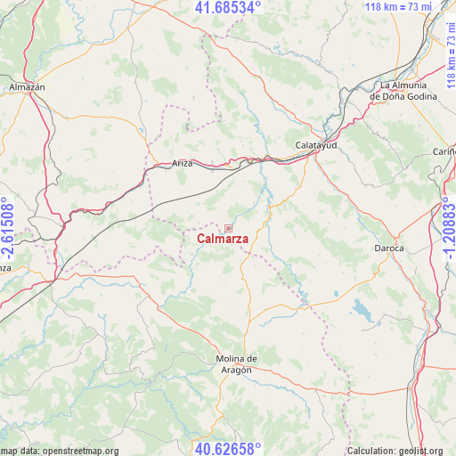
Calmarza GPS coordinates[2]
41° 9' 29.16" North, 1° 54' 43.056" West
| Map corner | latitude | longitude |
|---|---|---|
| Upper-left | 41.68534°, | -2.61508° |
| Center: | 41.1581°, | -1.91196° |
| Lower-right: | 40.62658°, | -1.20883° |
| Map W x H: | 117.7×117.7 km | = 73.1×73.1mi |
| max Lat: | 43.74134° ⇑47.8% North |
| Calmarza: | 41.1581° |
| min Lat: | ⇓52.2% South 27.64134° |
| min Long | Calmarza | max Long |
| -18.00367° | -1.91196° | 4.2899° |
| W 68.3%⇐ | ⇒31.7% E |
Elevation
Elevation of Calmarza is 843 m = 2766 ft, and this is 245 m = 804 ft above average elevation for this country.
| Max E: |
1682 m = 5518 ft | 26% |
| Calmarza | 843 m 2766 ft | |
| Avg. | 598 m = 1962 ft | |
Min E: |
0 m = 0 ft | 74% |
See also: Spain elevation on elevation.city.
Geographical zone
Calmarza is located in North temperate zone (between Tropic of Cancer and the Arctic Circle). Distance of this Northern Tropic circle is 1970.4 km =1224.3 mi to South.| Distance of | km | miles | from Calmarza |
|---|---|---|---|
| North Pole | 5430.7 | 3374.5 | to North |
| Arctic Circle | 2824.8 | 1755.2 | to North |
| Tropic Cancer | 1970.4 | 1224.3 | to South |
| Equator | 4576.4 | 2843.6 | to South |


Nearby cities:
15 places around Calmarza: (largest is in red/bold)
• Algar de Mesa
4.8 km =3 mi,  237°
237°
• Alhama de Aragón
15.5 km =9.6 mi,  5°
5°
• Cabolafuente
12.3 km =7.6 mi,  298°
298°
• Campillo de Aragón
6.7 km =4.2 mi,  121°
121°
• Cimballa
13.2 km =8.2 mi, 118°
• Fuentelsaz
11.6 km =7.2 mi,  144°
144°
• Godojos
12.9 km =8 mi,  18°
18°
• Ibdes
9.3 km =5.8 mi,  45°
45°
• Jaraba
4.3 km =2.7 mi,  32°
32°
• Milmarcos
8.5 km =5.3 mi,  159°
159°
• Mochales
11.1 km =6.9 mi,  231°
231°
• Monterde
14.9 km =9.3 mi,  83°
83°
• Nuévalos
11.9 km =7.4 mi,  59°
59°
• Sisamón
7.8 km =4.8 mi,  280°
280°
• Villel de Mesa
7.5 km =4.7 mi, 241°
Sources, notices
• [Note1] Compared only with cities in Spain existing in our database
• [Src1] Map data: © OpenStreetMap contributors (CC-BY-SA)
• [Src2] Other city data from geonames.org with taken over terms of usage.
• [Src3] Geographical zone / Annual Mean Temperature by Robert A. Rohde @ Wikipedia
