Godojos geodata
Godojos (Aragon) is a seat of a third-order administrative division; located in Spain in Europe/Madrid (GMT+2) time zone. With population of 55 people, there are 6410 cities with bigger population in this country. Compared to other cities in Spain, 54.8% of cities are located further ↓South; 68.8% of cities are located further ←West and 63.2% of cities have lower elevation than Godojos. Note1


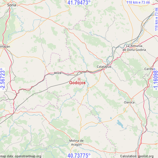
Godojos GPS coordinates[2]
41° 16' 6.168" North, 1° 51' 50.76" West
| Map corner | latitude | longitude |
|---|---|---|
| Upper-left | 41.79473°, | -2.56723° |
| Center: | 41.26838°, | -1.8641° |
| Lower-right: | 40.73775°, | -1.16098° |
| Map W x H: | 117.5×117.5 km | = 73×73mi |
| max Lat: | 43.74134° ⇑45.2% North |
| Godojos: | 41.26838° |
| min Lat: | ⇓54.8% South 27.64134° |
| min Long | Godojos | max Long |
| -18.00367° | -1.8641° | 4.2899° |
| W 68.8%⇐ | ⇒31.2% E |
Elevation
Elevation of Godojos is 766 m = 2513 ft, and this is 168 m = 551 ft above average elevation for this country.
| Max E: |
1682 m = 5518 ft | 36.8% |
| Godojos | 766 m 2513 ft | |
| Avg. | 598 m = 1962 ft | |
Min E: |
0 m = 0 ft | 63.2% |
See also: Spain elevation on elevation.city.
Geographical zone
Godojos is located in North temperate zone (between Tropic of Cancer and the Arctic Circle). Distance of this Northern Tropic circle is 1982.7 km =1232 mi to South.| Distance of | km | miles | from Godojos |
|---|---|---|---|
| North Pole | 5418.4 | 3366.8 | to North |
| Arctic Circle | 2812.6 | 1747.7 | to North |
| Tropic Cancer | 1982.7 | 1232 | to South |
| Equator | 4588.6 | 2851.2 | to South |


Nearby cities:
15 places around Godojos: (largest is in red/bold)
• Alhama de Aragón
4 km =2.5 mi,  321°
321°
• Ateca
9.1 km =5.7 mi,  40°
40°
• Bubierca
5.2 km =3.2 mi,  9°
9°
• Calmarza
12.9 km =8 mi,  198°
198°
• Carenas
5.7 km =3.5 mi,  79°
79°
• Castejón de las Armas
6.4 km =4 mi, 44°
• Cetina
8.7 km =5.4 mi,  287°
287°
• Contamina
6.1 km =3.8 mi,  312°
312°
• Ibdes
6.3 km =3.9 mi,  155°
155°
• Jaraba
8.8 km =5.5 mi,  191°
191°
• Moros
14.7 km =9.1 mi, 11°
• Munébrega
13.4 km =8.3 mi,  97°
97°
• Nuévalos
8.9 km =5.5 mi,  135°
135°
• Terrer
14.2 km =8.8 mi,  62°
62°
• Valtorres
10.8 km =6.7 mi,  71°
71°
Sources, notices
• [Note1] Compared only with cities in Spain existing in our database
• [Src1] Map data: © OpenStreetMap contributors (CC-BY-SA)
• [Src2] Other city data from geonames.org with taken over terms of usage.
• [Src3] Geographical zone / Annual Mean Temperature by Robert A. Rohde @ Wikipedia
