Ibdes geodata
Ibdes (Aragon) is a seat of a third-order administrative division; located in Spain in Europe/Madrid (GMT+2) time zone. With population of 550 people, there are 3739 cities with bigger population in this country. Compared to other cities in Spain, 53.6% of cities are located further ↓South; 69.1% of cities are located further ←West and 57.1% of cities have lower elevation than Ibdes. Note1


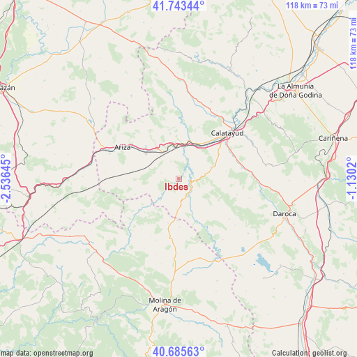
Ibdes GPS coordinates[2]
41° 13' 0.012" North, 1° 49' 59.988" West
| Map corner | latitude | longitude |
|---|---|---|
| Upper-left | 41.74344°, | -2.53645° |
| Center: | 41.21667°, | -1.83333° |
| Lower-right: | 40.68563°, | -1.1302° |
| Map W x H: | 117.6×117.6 km | = 73.1×73.1mi |
| max Lat: | 43.74134° ⇑46.4% North |
| Ibdes: | 41.21667° |
| min Lat: | ⇓53.6% South 27.64134° |
| min Long | Ibdes | max Long |
| -18.00367° | -1.83333° | 4.2899° |
| W 69.1%⇐ | ⇒30.9% E |
Elevation
Elevation of Ibdes is 724 m = 2375 ft, and this is 126 m = 413 ft above average elevation for this country.
| Max E: |
1682 m = 5518 ft | 42.9% |
| Ibdes | 724 m 2375 ft | |
| Avg. | 598 m = 1962 ft | |
Min E: |
0 m = 0 ft | 57.1% |
See also: Spain elevation on elevation.city.
Geographical zone
Ibdes is located in North temperate zone (between Tropic of Cancer and the Arctic Circle). Distance of this Northern Tropic circle is 1976.9 km =1228.4 mi to South.| Distance of | km | miles | from Ibdes |
|---|---|---|---|
| North Pole | 5424.2 | 3370.4 | to North |
| Arctic Circle | 2818.3 | 1751.2 | to North |
| Tropic Cancer | 1976.9 | 1228.4 | to South |
| Equator | 4582.9 | 2847.7 | to South |


Nearby cities:
15 places around Ibdes: (largest is in red/bold)
• Alhama de Aragón
10.2 km =6.3 mi,  330°
330°
• Ateca
13.1 km =8.1 mi,  14°
14°
• Bubierca
11 km =6.8 mi,  351°
351°
• Calmarza
9.3 km =5.8 mi,  225°
225°
• Campillo de Aragón
10.1 km =6.3 mi,  185°
185°
• Carenas
7.4 km =4.6 mi,  23°
23°
• Castejón de las Armas
10.5 km =6.5 mi, 10°
• Cetina
13.7 km =8.5 mi,  307°
307°
• Contamina
12.1 km =7.5 mi,  324°
324°
• Godojos
6.3 km =3.9 mi,  335°
335°
• Jaraba
5.1 km =3.2 mi,  236°
236°
• Monterde
9.5 km =5.9 mi,  119°
119°
• Munébrega
11.4 km =7.1 mi,  69°
69°
• Nuévalos
3.7 km =2.3 mi,  98°
98°
• Valtorres
11.9 km =7.4 mi,  40°
40°
Sources, notices
• [Note1] Compared only with cities in Spain existing in our database
• [Src1] Map data: © OpenStreetMap contributors (CC-BY-SA)
• [Src2] Other city data from geonames.org with taken over terms of usage.
• [Src3] Geographical zone / Annual Mean Temperature by Robert A. Rohde @ Wikipedia
