Monterde geodata
Monterde (Aragon) is a seat of a third-order administrative division; located in Spain in Europe/Madrid (GMT+2) time zone. With population of 235 people, there are 4834 cities with bigger population in this country. Compared to other cities in Spain, 52.6% of cities are located further ↓South; 70.2% of cities are located further ←West and 68% of cities have lower elevation than Monterde. Note1


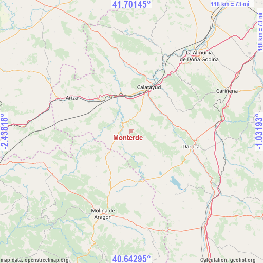
Monterde GPS coordinates[2]
41° 10' 27.624" North, 1° 44' 6.18" West
| Map corner | latitude | longitude |
|---|---|---|
| Upper-left | 41.70145°, | -2.43818° |
| Center: | 41.17434°, | -1.73505° |
| Lower-right: | 40.64295°, | -1.03193° |
| Map W x H: | 117.7×117.7 km | = 73.1×73.1mi |
| max Lat: | 43.74134° ⇑47.4% North |
| Monterde: | 41.17434° |
| min Lat: | ⇓52.6% South 27.64134° |
| min Long | Monterde | max Long |
| -18.00367° | -1.73505° | 4.2899° |
| W 70.2%⇐ | ⇒29.8% E |
Elevation
Elevation of Monterde is 799 m = 2621 ft, and this is 201 m = 659 ft above average elevation for this country.
| Max E: |
1682 m = 5518 ft | 32% |
| Monterde | 799 m 2621 ft | |
| Avg. | 598 m = 1962 ft | |
Min E: |
0 m = 0 ft | 68% |
See also: Spain elevation on elevation.city.
Geographical zone
Monterde is located in North temperate zone (between Tropic of Cancer and the Arctic Circle). Distance of this Northern Tropic circle is 1972.2 km =1225.5 mi to South.| Distance of | km | miles | from Monterde |
|---|---|---|---|
| North Pole | 5428.9 | 3373.4 | to North |
| Arctic Circle | 2823 | 1754.1 | to North |
| Tropic Cancer | 1972.2 | 1225.5 | to South |
| Equator | 4578.2 | 2844.8 | to South |


Nearby cities:
15 places around Monterde: (largest is in red/bold)
• Abanto
5.1 km =3.2 mi,  142°
142°
• Acered
11 km =6.8 mi,  92°
92°
• Alarba
10.7 km =6.6 mi,  71°
71°
• Aldehuela de Liestos
12.6 km =7.8 mi,  166°
166°
• Campillo de Aragón
10.6 km =6.6 mi,  239°
239°
• Carenas
12.6 km =7.8 mi,  335°
335°
• Castejón de Alarba
8.3 km =5.2 mi,  82°
82°
• Cimballa
8.7 km =5.4 mi,  201°
201°
• Cubel
12 km =7.5 mi, 136°
• Fuentelsaz
13.8 km =8.6 mi,  215°
215°
• Ibdes
9.5 km =5.9 mi,  299°
299°
• Jaraba
12.6 km =7.8 mi,  278°
278°
• Munébrega
9 km =5.6 mi,  15°
15°
• Nuévalos
6.2 km =3.9 mi,  312°
312°
• Olvés
10.4 km =6.5 mi,  45°
45°
Sources, notices
• [Note1] Compared only with cities in Spain existing in our database
• [Src1] Map data: © OpenStreetMap contributors (CC-BY-SA)
• [Src2] Other city data from geonames.org with taken over terms of usage.
• [Src3] Geographical zone / Annual Mean Temperature by Robert A. Rohde @ Wikipedia
