Brunete geodata
Brunete (Madrid) is a seat of a third-order administrative division; located in Spain in Europe/Madrid (GMT+2) time zone. With population of 7,799 people, there are 955 cities with bigger population in this country. Compared to other cities in Spain, 63.9% of cities are located further ↑North; 59.7% of cities are located further →East and 50.4% of cities have higher elevation than Brunete. Note1


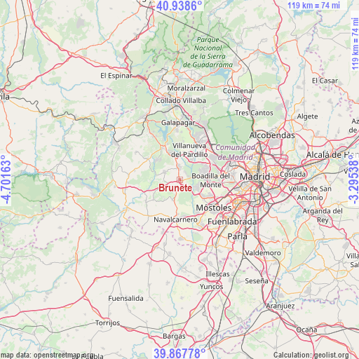
Brunete GPS coordinates[2]
40° 24' 19.152" North, 3° 59' 54.6" West
| Map corner | latitude | longitude |
|---|---|---|
| Upper-left | 40.9386°, | -4.70163° |
| Center: | 40.40532°, | -3.9985° |
| Lower-right: | 39.86778°, | -3.29538° |
| Map W x H: | 119.1×119.1 km | = 74×74mi |
| max Lat: | 43.74134° ⇑63.9% North |
| Brunete: | 40.40532° |
| min Lat: | ⇓36.1% South 27.64134° |
| min Long | Brunete | max Long |
| -18.00367° | -3.9985° | 4.2899° |
| W 40.3%⇐ | ⇒59.7% E |
Elevation
Elevation of Brunete is 654 m = 2146 ft, and this is 56 m = 184 ft above average elevation for this country.
| Max E: |
1682 m = 5518 ft | 50.4% |
| Brunete | 654 m 2146 ft | |
| Avg. | 598 m = 1962 ft | |
Min E: |
0 m = 0 ft | 49.6% |
See also: Spain elevation on elevation.city.
Geographical zone
Brunete is located in North temperate zone (between Tropic of Cancer and the Arctic Circle). Distance of this Northern Tropic circle is 1886.7 km =1172.3 mi to South.| Distance of | km | miles | from Brunete |
|---|---|---|---|
| North Pole | 5514.4 | 3426.5 | to North |
| Arctic Circle | 2908.5 | 1807.3 | to North |
| Tropic Cancer | 1886.7 | 1172.3 | to South |
| Equator | 4492.7 | 2791.6 | to South |


Nearby cities:
15 places around Brunete: (largest is in red/bold)
• Boadilla del Monte
10.2 km =6.3 mi,  90°
90°
• Las Rozas de Madrid
14.4 km =8.9 mi,  47°
47°
• Majadahonda
13.1 km =8.1 mi, 54°
• Móstoles
14.6 km =9.1 mi,  129°
129°
• Navalagamella
12.7 km =7.9 mi,  303°
303°
• Navalcarnero
13 km =8.1 mi,  185°
185°
• Quijorna
5.5 km =3.4 mi, 296°
• Sevilla La Nueva
6.8 km =4.2 mi,  200°
200°
• Valdemorillo
12.1 km =7.5 mi,  331°
331°
• Villamanta
15.1 km =9.4 mi,  218°
218°
• Villamantilla
13.4 km =8.3 mi,  236°
236°
• Villanueva de Perales
10.8 km =6.7 mi,  231°
231°
• Villanueva de la Cañada
4.6 km =2.9 mi,  353°
353°
• Villanueva del Pardillo
9.9 km =6.2 mi,  17°
17°
• Villaviciosa de Odón
9.6 km =6 mi,  123°
123°
Sources, notices
• [Note1] Compared only with cities in Spain existing in our database
• [Src1] Map data: © OpenStreetMap contributors (CC-BY-SA)
• [Src2] Other city data from geonames.org with taken over terms of usage.
• [Src3] Geographical zone / Annual Mean Temperature by Robert A. Rohde @ Wikipedia
