Navalagamella geodata
Navalagamella (Madrid) is a seat of a third-order administrative division; located in Spain in Europe/Madrid (GMT+2) time zone. With population of 1,700 people, there are 2337 cities with bigger population in this country. Compared to other cities in Spain, 62.5% of cities are located further ↑North; 61.6% of cities are located further →East and 62.4% of cities have lower elevation than Navalagamella. Note1


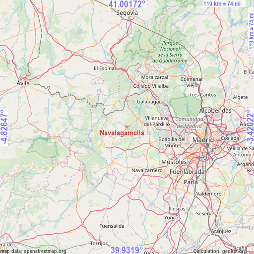
Navalagamella GPS coordinates[2]
40° 28' 8.184" North, 4° 7' 24.024" West
| Map corner | latitude | longitude |
|---|---|---|
| Upper-left | 41.00172°, | -4.82647° |
| Center: | 40.46894°, | -4.12334° |
| Lower-right: | 39.9319°, | -3.42022° |
| Map W x H: | 119×119 km | = 73.9×73.9mi |
| max Lat: | 43.74134° ⇑62.5% North |
| Navalagamella: | 40.46894° |
| min Lat: | ⇓37.5% South 27.64134° |
| min Long | Navalagamella | max Long |
| -18.00367° | -4.12334° | 4.2899° |
| W 38.4%⇐ | ⇒61.6% E |
Elevation
Elevation of Navalagamella is 760 m = 2493 ft, and this is 162 m = 531 ft above average elevation for this country.
| Max E: |
1682 m = 5518 ft | 37.6% |
| Navalagamella | 760 m 2493 ft | |
| Avg. | 598 m = 1962 ft | |
Min E: |
0 m = 0 ft | 62.4% |
See also: Spain elevation on elevation.city.
Geographical zone
Navalagamella is located in North temperate zone (between Tropic of Cancer and the Arctic Circle). Distance of this Northern Tropic circle is 1893.8 km =1176.8 mi to South.| Distance of | km | miles | from Navalagamella |
|---|---|---|---|
| North Pole | 5507.3 | 3422.1 | to North |
| Arctic Circle | 2901.4 | 1802.8 | to North |
| Tropic Cancer | 1893.8 | 1176.8 | to South |
| Equator | 4499.7 | 2796 | to South |


Nearby cities:
15 places around Navalagamella: (largest is in red/bold)
• Brunete
12.7 km =7.9 mi,  123°
123°
• Chapinería
12.4 km =7.7 mi,  216°
216°
• Colmenar del Arroyo
8.4 km =5.2 mi,  228°
228°
• Colmenarejo
13.6 km =8.5 mi,  41°
41°
• El Escorial
12.6 km =7.8 mi,  358°
358°
• Fresnedillas
4.5 km =2.8 mi,  296°
296°
• Navas del Rey
14.2 km =8.8 mi, 229°
• Quijorna
7.3 km =4.5 mi,  129°
129°
• Robledo de Chavela
10.2 km =6.3 mi,  290°
290°
• San Lorenzo de El Escorial
13.8 km =8.6 mi,  351°
351°
• Valdemorillo
5.9 km =3.7 mi,  53°
53°
• Villanueva de Perales
13.9 km =8.6 mi,  171°
171°
• Villanueva de la Cañada
10.4 km =6.5 mi,  103°
103°
• Villanueva del Pardillo
13.7 km =8.5 mi,  80°
80°
• Zarzalejo
10.1 km =6.3 mi,  330°
330°
Sources, notices
• [Note1] Compared only with cities in Spain existing in our database
• [Src1] Map data: © OpenStreetMap contributors (CC-BY-SA)
• [Src2] Other city data from geonames.org with taken over terms of usage.
• [Src3] Geographical zone / Annual Mean Temperature by Robert A. Rohde @ Wikipedia
