Sevilla La Nueva geodata
Sevilla La Nueva (Madrid) is a populated place; located in Spain in Europe/Madrid (GMT+2) time zone. With population of 6,445 people, there are 1089 cities with bigger population in this country. Compared to other cities in Spain, 64.9% of cities are located further ↑North; 60.2% of cities are located further →East and 51.5% of cities have lower elevation than Sevilla La Nueva. Note1


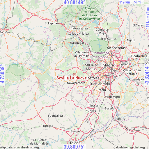
Sevilla La Nueva GPS coordinates[2]
40° 20' 51.9" North, 4° 1' 38.172" West
| Map corner | latitude | longitude |
|---|---|---|
| Upper-left | 40.88149°, | -4.73039° |
| Center: | 40.34775°, | -4.02727° |
| Lower-right: | 39.80975°, | -3.32414° |
| Map W x H: | 119.2×119.2 km | = 74.1×74.1mi |
| max Lat: | 43.74134° ⇑64.9% North |
| Sevilla La Nueva: | 40.34775° |
| min Lat: | ⇓35.1% South 27.64134° |
| min Long | Sevilla La Nuev | max Long |
| -18.00367° | -4.02727° | 4.2899° |
| W 39.8%⇐ | ⇒60.2% E |
Elevation
Elevation of Sevilla La Nueva is 675 m = 2215 ft, and this is 77 m = 253 ft above average elevation for this country.
| Max E: |
1682 m = 5518 ft | 48.5% |
| Sevilla La Nueva | 675 m 2215 ft | |
| Avg. | 598 m = 1962 ft | |
Min E: |
0 m = 0 ft | 51.5% |
See also: Spain elevation on elevation.city.
Geographical zone
Sevilla La Nueva is located in North temperate zone (between Tropic of Cancer and the Arctic Circle). Distance of this Northern Tropic circle is 1880.3 km =1168.4 mi to South.| Distance of | km | miles | from Sevilla La Nueva |
|---|---|---|---|
| North Pole | 5520.8 | 3430.5 | to North |
| Arctic Circle | 2914.9 | 1811.2 | to North |
| Tropic Cancer | 1880.3 | 1168.4 | to South |
| Equator | 4486.2 | 2787.6 | to South |


Nearby cities:
15 places around Sevilla La Nueva: (largest is in red/bold)
• Aldea del Fresno
15.2 km =9.4 mi,  259°
259°
• Arroyomolinos
12.6 km =7.8 mi,  133°
133°
• Boadilla del Monte
14.1 km =8.8 mi,  63°
63°
• Brunete
6.8 km =4.2 mi,  20°
20°
• Chapinería
15.9 km =9.9 mi,  282°
282°
• El Álamo
13.3 km =8.3 mi,  167°
167°
• Móstoles
14 km =8.7 mi,  101°
101°
• Navalagamella
15.7 km =9.8 mi,  328°
328°
• Navalcarnero
6.7 km =4.2 mi, 168°
• Quijorna
9.2 km =5.7 mi,  344°
344°
• Villamanta
8.8 km =5.5 mi,  231°
231°
• Villamantilla
8.8 km =5.5 mi, 263°
• Villanueva de Perales
6.1 km =3.8 mi,  267°
267°
• Villanueva de la Cañada
11.2 km =7 mi,  10°
10°
• Villaviciosa de Odón
10.5 km =6.5 mi,  83°
83°
Sources, notices
• [Note1] Compared only with cities in Spain existing in our database
• [Src1] Map data: © OpenStreetMap contributors (CC-BY-SA)
• [Src2] Other city data from geonames.org with taken over terms of usage.
• [Src3] Geographical zone / Annual Mean Temperature by Robert A. Rohde @ Wikipedia
