Villaviciosa de Odón geodata
Villaviciosa de Odón (Madrid) is a seat of a third-order administrative division; located in Spain in Europe/Madrid (GMT+2) time zone. With population of 26,475 people, there are 353 cities with bigger population in this country. Compared to other cities in Spain, 64.7% of cities are located further ↑North; 58.3% of cities are located further →East and 51% of cities have higher elevation than Villaviciosa de Odón. Note1
Administrative division(s):
- Level 1: Madrid
- Level 2: Provincia de Madrid
- Level 3: Villaviciosa de Odón


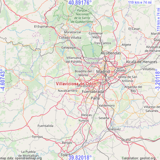
Villaviciosa de Odón GPS coordinates[2]
40° 21' 29.16" North, 3° 54' 15.48" West
| Map corner | latitude | longitude |
|---|---|---|
| Upper-left | 40.89176°, | -4.60743° |
| Center: | 40.3581°, | -3.9043° |
| Lower-right: | 39.82018°, | -3.20118° |
| Map W x H: | 119.1×119.1 km | = 74×74mi |
| max Lat: | 43.74134° ⇑64.7% North |
| Villaviciosa de Odón: | 40.3581° |
| min Lat: | ⇓35.3% South 27.64134° |
| min Long | Villaviciosa de | max Long |
| -18.00367° | -3.9043° | 4.2899° |
| W 41.7%⇐ | ⇒58.3% E |
Elevation
Elevation of Villaviciosa de Odón is 648 m = 2126 ft, and this is 50 m = 164 ft above average elevation for this country.
| Max E: |
1682 m = 5518 ft | 51% |
| Villaviciosa de Odón | 648 m 2126 ft | |
| Avg. | 598 m = 1962 ft | |
Min E: |
0 m = 0 ft | 49% |
See also: Spain elevation on elevation.city.
Geographical zone
Villaviciosa de Odón is located in North temperate zone (between Tropic of Cancer and the Arctic Circle). Distance of this Northern Tropic circle is 1881.5 km =1169.1 mi to South.| Distance of | km | miles | from Villaviciosa de Odón |
|---|---|---|---|
| North Pole | 5519.7 | 3429.8 | to North |
| Arctic Circle | 2913.8 | 1810.6 | to North |
| Tropic Cancer | 1881.5 | 1169.1 | to South |
| Equator | 4487.4 | 2788.3 | to South |


Nearby cities:
15 places around Villaviciosa de Odón: (largest is in red/bold)
• Alcorcón
6.9 km =4.3 mi,  101°
101°
• Arroyomolinos
9.9 km =6.2 mi,  187°
187°
• Boadilla del Monte
5.7 km =3.5 mi,  22°
22°
• Brunete
9.6 km =6 mi,  303°
303°
• Fuenlabrada
12.4 km =7.7 mi,  131°
131°
• Humanes de Madrid
13.5 km =8.4 mi,  152°
152°
• Latina
13.9 km =8.6 mi,  75°
75°
• Leganés
12.4 km =7.7 mi,  106°
106°
• Majadahonda
13.1 km =8.1 mi,  12°
12°
• Moraleja de Enmedio
11.4 km =7.1 mi,  160°
160°
• Móstoles
5.2 km =3.2 mi,  140°
140°
• Navalcarnero
11.9 km =7.4 mi,  229°
229°
• Pozuelo de Alarcón
11.3 km =7 mi,  42°
42°
• Sevilla La Nueva
10.5 km =6.5 mi,  263°
263°
• Villanueva de la Cañada
13 km =8.1 mi,  319°
319°
Sources, notices
• [Note1] Compared only with cities in Spain existing in our database
• [Src1] Map data: © OpenStreetMap contributors (CC-BY-SA)
• [Src2] Other city data from geonames.org with taken over terms of usage.
• [Src3] Geographical zone / Annual Mean Temperature by Robert A. Rohde @ Wikipedia
