Majadahonda geodata
Majadahonda (Madrid) is a seat of a third-order administrative division; located in Spain in Europe/Madrid (GMT+2) time zone. With population of 68,110 people, there are 134 cities with bigger population in this country. Compared to other cities in Spain, 62.4% of cities are located further ↑North; 57.9% of cities are located further →East and 59.7% of cities have lower elevation than Majadahonda. Note1


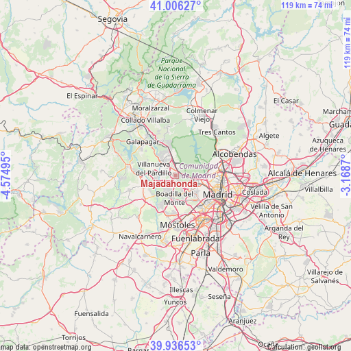
Majadahonda GPS coordinates[2]
40° 28' 24.708" North, 3° 52' 18.552" West
| Map corner | latitude | longitude |
|---|---|---|
| Upper-left | 41.00627°, | -4.57495° |
| Center: | 40.47353°, | -3.87182° |
| Lower-right: | 39.93653°, | -3.1687° |
| Map W x H: | 118.9×118.9 km | = 73.9×73.9mi |
| max Lat: | 43.74134° ⇑62.4% North |
| Majadahonda: | 40.47353° |
| min Lat: | ⇓37.6% South 27.64134° |
| min Long | Majadahonda | max Long |
| -18.00367° | -3.87182° | 4.2899° |
| W 42.1%⇐ | ⇒57.9% E |
Elevation
Elevation of Majadahonda is 743 m = 2438 ft, and this is 145 m = 476 ft above average elevation for this country.
| Max E: |
1682 m = 5518 ft | 40.3% |
| Majadahonda | 743 m 2438 ft | |
| Avg. | 598 m = 1962 ft | |
Min E: |
0 m = 0 ft | 59.7% |
See also: Majadahonda elevation on elevation.city.
Geographical zone
Majadahonda is located in North temperate zone (between Tropic of Cancer and the Arctic Circle). Distance of this Northern Tropic circle is 1894.3 km =1177.1 mi to South.| Distance of | km | miles | from Majadahonda |
|---|---|---|---|
| North Pole | 5506.8 | 3421.8 | to North |
| Arctic Circle | 2900.9 | 1802.5 | to North |
| Tropic Cancer | 1894.3 | 1177.1 | to South |
| Equator | 4500.2 | 2796.3 | to South |


Nearby cities:
15 places around Majadahonda: (largest is in red/bold)
• Alcorcón
14.7 km =9.1 mi,  164°
164°
• Boadilla del Monte
7.6 km =4.7 mi,  184°
184°
• Brunete
13.1 km =8.1 mi,  234°
234°
• El Pardo
9.6 km =6 mi,  61°
61°
• Fuencarral-El Pardo
12.2 km =7.6 mi,  76°
76°
• Las Matas
9.5 km =5.9 mi,  349°
349°
• Las Rozas de Madrid
2.2 km =1.4 mi,  355°
355°
• Latina
14.2 km =8.8 mi,  131°
131°
• Moncloa-Aravaca
12.6 km =7.8 mi,  109°
109°
• Pozuelo de Alarcón
6.7 km =4.2 mi, 132°
• Tetuán de las Victorias
14.8 km =9.2 mi,  95°
95°
• Torrelodones
12.4 km =7.7 mi,  337°
337°
• Villanueva de la Cañada
11.6 km =7.2 mi,  255°
255°
• Villanueva del Pardillo
8 km =5 mi,  283°
283°
• Villaviciosa de Odón
13.1 km =8.1 mi,  192°
192°
Sources, notices
• [Note1] Compared only with cities in Spain existing in our database
• [Src1] Map data: © OpenStreetMap contributors (CC-BY-SA)
• [Src2] Other city data from geonames.org with taken over terms of usage.
• [Src3] Geographical zone / Annual Mean Temperature by Robert A. Rohde @ Wikipedia
