Brazacorta geodata
Brazacorta (Castille and León) is a seat of a third-order administrative division; located in Spain in Europe/Madrid (GMT+2) time zone. With population of 87 people, there are 6070 cities with bigger population in this country. Compared to other cities in Spain, 66.5% of cities are located further ↓South; 50.4% of cities are located further →East and 81.5% of cities have lower elevation than Brazacorta. Note1
Administrative division(s):
- Level 1: Castille and León
- Level 2: Provincia de Burgos
- Level 3: Brazacorta


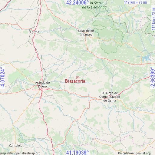
Brazacorta GPS coordinates[2]
41° 43' 2.532" North, 3° 22' 1.596" West
| Map corner | latitude | longitude |
|---|---|---|
| Upper-left | 42.24006°, | -4.07024° |
| Center: | 41.71737°, | -3.36711° |
| Lower-right: | 41.19039°, | -2.66399° |
| Map W x H: | 116.7×116.7 km | = 72.5×72.5mi |
| max Lat: | 43.74134° ⇑33.5% North |
| Brazacorta: | 41.71737° |
| min Lat: | ⇓66.5% South 27.64134° |
| min Long | Brazacorta | max Long |
| -18.00367° | -3.36711° | 4.2899° |
| W 49.6%⇐ | ⇒50.4% E |
Elevation
Elevation of Brazacorta is 912 m = 2992 ft, and this is 314 m = 1030 ft above average elevation for this country.
| Max E: |
1682 m = 5518 ft | 18.5% |
| Brazacorta | 912 m 2992 ft | |
| Avg. | 598 m = 1962 ft | |
Min E: |
0 m = 0 ft | 81.5% |
See also: Spain elevation on elevation.city.
Geographical zone
Brazacorta is located in North temperate zone (between Tropic of Cancer and the Arctic Circle). Distance of this Northern Tropic circle is 2032.6 km =1263 mi to South.| Distance of | km | miles | from Brazacorta |
|---|---|---|---|
| North Pole | 5368.5 | 3335.8 | to North |
| Arctic Circle | 2762.6 | 1716.6 | to North |
| Tropic Cancer | 2032.6 | 1263 | to South |
| Equator | 4638.5 | 2882.2 | to South |


Nearby cities:
15 places around Brazacorta: (largest is in red/bold)
• Alcubilla de Avellaneda
5.3 km =3.3 mi,  79°
79°
• Arandilla
5.6 km =3.5 mi,  293°
293°
• Arauzo de Salce
11.9 km =7.4 mi,  341°
341°
• Arauzo de Torre
10.1 km =6.3 mi,  332°
332°
• Caleruega
15.5 km =9.6 mi,  320°
320°
• Coruña del Conde
5.7 km =3.5 mi, 340°
• Espeja de San Marcelino
15.3 km =9.5 mi,  51°
51°
• Espejón
15.4 km =9.6 mi,  35°
35°
• Fuentearmegil
15.2 km =9.4 mi,  91°
91°
• Hontoria de Valdearados
13 km =8.1 mi,  283°
283°
• Huerta del Rey
13.6 km =8.5 mi,  6°
6°
• Langa de Duero
12.3 km =7.6 mi,  193°
193°
• Peñaranda de Duero
9.8 km =6.1 mi,  250°
250°
• San Juan del Monte
13.5 km =8.4 mi, 253°
• Zazuar
15.7 km =9.8 mi,  261°
261°
Sources, notices
• [Note1] Compared only with cities in Spain existing in our database
• [Src1] Map data: © OpenStreetMap contributors (CC-BY-SA)
• [Src2] Other city data from geonames.org with taken over terms of usage.
• [Src3] Geographical zone / Annual Mean Temperature by Robert A. Rohde @ Wikipedia
