Boltaña geodata
Boltaña (Aragon) is a seat of a third-order administrative division; located in Spain in Europe/Madrid (GMT+2) time zone. With population of 897 people, there are 3071 cities with bigger population in this country. Compared to other cities in Spain, 86% of cities are located further ↓South; 87.4% of cities are located further ←West and 50.4% of cities have higher elevation than Boltaña. Note1


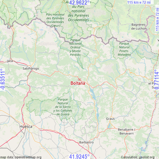
Boltaña GPS coordinates[2]
42° 26' 43.8" North, 0° 4' 4.872" East
| Map corner | latitude | longitude |
|---|---|---|
| Upper-left | 42.9622°, | -0.63511° |
| Center: | 42.4455°, | 0.06802° |
| Lower-right: | 41.9245°, | 0.77114° |
| Map W x H: | 115.4×115.4 km | = 71.7×71.7mi |
| max Lat: | 43.74134° ⇑14% North |
| Boltaña: | 42.4455° |
| min Lat: | ⇓86% South 27.64134° |
| min Long | Boltaña | max Long |
| -18.00367° | 0.06802° | 4.2899° |
| W 87.4%⇐ | ⇒12.6% E |
Elevation
Elevation of Boltaña is 654 m = 2146 ft, and this is 56 m = 184 ft above average elevation for this country.
| Max E: |
1682 m = 5518 ft | 50.4% |
| Boltaña | 654 m 2146 ft | |
| Avg. | 598 m = 1962 ft | |
Min E: |
0 m = 0 ft | 49.6% |
See also: Spain elevation on elevation.city.
Geographical zone
Boltaña is located in North temperate zone (between Tropic of Cancer and the Arctic Circle). Distance of this Northern Tropic circle is 2113.6 km =1313.3 mi to South.| Distance of | km | miles | from Boltaña |
|---|---|---|---|
| North Pole | 5287.6 | 3285.6 | to North |
| Arctic Circle | 2681.7 | 1666.3 | to North |
| Tropic Cancer | 2113.6 | 1313.3 | to South |
| Equator | 4719.5 | 2932.6 | to South |


Nearby cities:
15 places around Boltaña: (largest is in red/bold)
• Abizanda
25 km =15.5 mi,  154°
154°
• Aínsa
6.8 km =4.2 mi,  119°
119°
• Bielsa
24.3 km =15.1 mi,  30°
30°
• Broto
23.6 km =14.7 mi,  318°
318°
• Bárcabo
22.6 km =14 mi,  179°
179°
• Campo
27.2 km =16.9 mi,  98°
98°
• Fiscal
16.5 km =10.3 mi,  289°
289°
• Gistaín
27.2 km =16.9 mi,  53°
53°
• Labuerda
5.6 km =3.5 mi,  82°
82°
• Laspuña
9.6 km =6 mi, 47°
• Naval
28.7 km =17.8 mi,  166°
166°
• Palo
19.9 km =12.4 mi,  133°
133°
• Plan
26.7 km =16.6 mi,  55°
55°
• Puértolas
12.5 km =7.8 mi,  24°
24°
• Yebra de Basa
29.1 km =18.1 mi,  279°
279°
Sources, notices
• [Note1] Compared only with cities in Spain existing in our database
• [Src1] Map data: © OpenStreetMap contributors (CC-BY-SA)
• [Src2] Other city data from geonames.org with taken over terms of usage.
• [Src3] Geographical zone / Annual Mean Temperature by Robert A. Rohde @ Wikipedia
