Broto geodata
Broto (Aragon) is a seat of a third-order administrative division; located in Spain in Europe/Madrid (GMT+2) time zone. With population of 509 people, there are 3858 cities with bigger population in this country. Compared to other cities in Spain, 89.6% of cities are located further ↓South; 86.3% of cities are located further ←West and 79.8% of cities have lower elevation than Broto. Note1


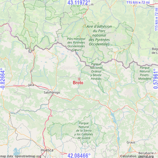
Broto GPS coordinates[2]
42° 36' 15.624" North, 0° 7' 24.636" West
| Map corner | latitude | longitude |
|---|---|---|
| Upper-left | 43.11972°, | -0.82664° |
| Center: | 42.60434°, | -0.12351° |
| Lower-right: | 42.08466°, | 0.57961° |
| Map W x H: | 115.1×115.1 km | = 71.5×71.5mi |
| max Lat: | 43.74134° ⇑10.4% North |
| Broto: | 42.60434° |
| min Lat: | ⇓89.6% South 27.64134° |
| min Long | Broto | max Long |
| -18.00367° | -0.12351° | 4.2899° |
| W 86.3%⇐ | ⇒13.7% E |
Elevation
Elevation of Broto is 895 m = 2936 ft, and this is 297 m = 974 ft above average elevation for this country.
| Max E: |
1682 m = 5518 ft | 20.2% |
| Broto | 895 m 2936 ft | |
| Avg. | 598 m = 1962 ft | |
Min E: |
0 m = 0 ft | 79.8% |
See also: Spain elevation on elevation.city.
Geographical zone
Broto is located in North temperate zone (between Tropic of Cancer and the Arctic Circle). Distance of this Northern Tropic circle is 2131.2 km =1324.3 mi to South.| Distance of | km | miles | from Broto |
|---|---|---|---|
| North Pole | 5269.9 | 3274.6 | to North |
| Arctic Circle | 2664 | 1655.3 | to North |
| Tropic Cancer | 2131.2 | 1324.3 | to South |
| Equator | 4737.2 | 2943.6 | to South |


Nearby cities:
15 places around Broto: (largest is in red/bold)
• Aínsa
30.1 km =18.7 mi,  134°
134°
• Bielsa
28.2 km =17.5 mi,  83°
83°
• Biescas
16.4 km =10.2 mi,  279°
279°
• Boltaña
23.6 km =14.7 mi,  138°
138°
• Fiscal
12.1 km =7.5 mi,  179°
179°
• Hoz de Jaca
17.8 km =11.1 mi,  302°
302°
• Labuerda
27.1 km =16.8 mi, 128°
• Laspuña
25.4 km =15.8 mi,  116°
116°
• Panticosa
18.5 km =11.5 mi,  315°
315°
• Puértolas
21.9 km =13.6 mi,  106°
106°
• Sabiñánigo
22 km =13.7 mi,  244°
244°
• Sallent de Gállego
25.3 km =15.7 mi, 317°
• Villanúa
34.9 km =21.7 mi, 283°
• Yebra de Basa
18.4 km =11.4 mi,  224°
224°
• Yésero
10.5 km =6.5 mi, 279°
Sources, notices
• [Note1] Compared only with cities in Spain existing in our database
• [Src1] Map data: © OpenStreetMap contributors (CC-BY-SA)
• [Src2] Other city data from geonames.org with taken over terms of usage.
• [Src3] Geographical zone / Annual Mean Temperature by Robert A. Rohde @ Wikipedia
