Palo geodata
Palo (Aragon) is a seat of a third-order administrative division; located in Spain in Europe/Madrid (GMT+2) time zone. With population of 29 people, there are 6669 cities with bigger population in this country. Compared to other cities in Spain, 82.5% of cities are located further ↓South; 88.1% of cities are located further ←West and 54.6% of cities have lower elevation than Palo. Note1


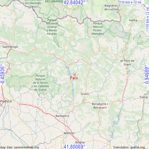
Palo GPS coordinates[2]
42° 19' 21.72" North, 0° 14' 37.536" East
| Map corner | latitude | longitude |
|---|---|---|
| Upper-left | 42.84042°, | -0.45936° |
| Center: | 42.3227°, | 0.24376° |
| Lower-right: | 41.80069°, | 0.94689° |
| Map W x H: | 115.6×115.6 km | = 71.8×71.8mi |
| max Lat: | 43.74134° ⇑17.5% North |
| Palo: | 42.3227° |
| min Lat: | ⇓82.5% South 27.64134° |
| min Long | Palo | max Long |
| -18.00367° | 0.24376° | 4.2899° |
| W 88.1%⇐ | ⇒11.9% E |
Elevation
Elevation of Palo is 705 m = 2313 ft, and this is 107 m = 351 ft above average elevation for this country.
| Max E: |
1682 m = 5518 ft | 45.4% |
| Palo | 705 m 2313 ft | |
| Avg. | 598 m = 1962 ft | |
Min E: |
0 m = 0 ft | 54.6% |
See also: Spain elevation on elevation.city.
Geographical zone
Palo is located in North temperate zone (between Tropic of Cancer and the Arctic Circle). Distance of this Northern Tropic circle is 2099.9 km =1304.8 mi to South.| Distance of | km | miles | from Palo |
|---|---|---|---|
| North Pole | 5301.2 | 3294 | to North |
| Arctic Circle | 2695.3 | 1674.8 | to North |
| Tropic Cancer | 2099.9 | 1304.8 | to South |
| Equator | 4705.8 | 2924 | to South |


Nearby cities:
15 places around Palo: (largest is in red/bold)
• Abizanda
9.7 km =6 mi,  203°
203°
• Alquézar
24.5 km =15.2 mi,  227°
227°
• Aínsa
13.4 km =8.3 mi,  320°
320°
• Boltaña
19.9 km =12.4 mi,  313°
313°
• Bárcabo
16.9 km =10.5 mi,  238°
238°
• Campo
15.8 km =9.8 mi,  52°
52°
• Capella
18.8 km =11.7 mi,  138°
138°
• Colungo
22.2 km =13.8 mi,  220°
220°
• El Grado
19.2 km =11.9 mi,  185°
185°
• Graus
16.8 km =10.4 mi,  152°
152°
• Labuerda
16.9 km =10.5 mi,  328°
328°
• Laspuña
21.4 km =13.3 mi,  339°
339°
• Naval
16.1 km =10 mi,  208°
208°
• Secastilla
15.9 km =9.9 mi,  172°
172°
• Seira
23 km =14.3 mi,  41°
41°
Sources, notices
• [Note1] Compared only with cities in Spain existing in our database
• [Src1] Map data: © OpenStreetMap contributors (CC-BY-SA)
• [Src2] Other city data from geonames.org with taken over terms of usage.
• [Src3] Geographical zone / Annual Mean Temperature by Robert A. Rohde @ Wikipedia
