Blacos geodata
Blacos (Castille and León) is a seat of a third-order administrative division; located in Spain in Europe/Madrid (GMT+2) time zone. With population of 57 people, there are 6380 cities with bigger population in this country. Compared to other cities in Spain, 65.5% of cities are located further ↓South; 56.6% of cities are located further ←West and 88.1% of cities have lower elevation than Blacos. Note1


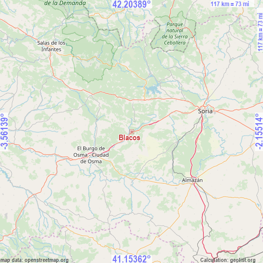
Blacos GPS coordinates[2]
41° 40' 51.24" North, 2° 51' 29.736" West
| Map corner | latitude | longitude |
|---|---|---|
| Upper-left | 42.20389°, | -3.56139° |
| Center: | 41.6809°, | -2.85826° |
| Lower-right: | 41.15362°, | -2.15514° |
| Map W x H: | 116.8×116.8 km | = 72.6×72.6mi |
| max Lat: | 43.74134° ⇑34.5% North |
| Blacos: | 41.6809° |
| min Lat: | ⇓65.5% South 27.64134° |
| min Long | Blacos | max Long |
| -18.00367° | -2.85826° | 4.2899° |
| W 56.6%⇐ | ⇒43.4% E |
Elevation
Elevation of Blacos is 1000 m = 3281 ft, and this is 402 m = 1319 ft above average elevation for this country.
| Max E: |
1682 m = 5518 ft | 11.9% |
| Blacos | 1000 m 3281 ft | |
| Avg. | 598 m = 1962 ft | |
Min E: |
0 m = 0 ft | 88.1% |
See also: Spain elevation on elevation.city.
Geographical zone
Blacos is located in North temperate zone (between Tropic of Cancer and the Arctic Circle). Distance of this Northern Tropic circle is 2028.6 km =1260.5 mi to South.| Distance of | km | miles | from Blacos |
|---|---|---|---|
| North Pole | 5372.6 | 3338.4 | to North |
| Arctic Circle | 2766.7 | 1719.1 | to North |
| Tropic Cancer | 2028.6 | 1260.5 | to South |
| Equator | 4634.5 | 2879.7 | to South |


Nearby cities:
15 places around Blacos: (largest is in red/bold)
• Abejar
15.4 km =9.6 mi,  23°
23°
• Bayubas de Arriba
13.9 km =8.6 mi,  189°
189°
• Cabrejas del Pinar
12.8 km =8 mi,  3°
3°
• Calatañazor
3.9 km =2.4 mi,  59°
59°
• Cubilla
10 km =6.2 mi,  319°
319°
• Fuentepinilla
15 km =9.3 mi,  147°
147°
• Herrera de Soria
15.7 km =9.8 mi,  305°
305°
• Muriel Viejo
12.3 km =7.6 mi,  337°
337°
• Muriel de la Fuente
4.7 km =2.9 mi,  358°
358°
• Tajueco
16.1 km =10 mi,  177°
177°
• Torreblacos
2.1 km =1.3 mi,  232°
232°
• Ucero
16.5 km =10.3 mi,  283°
283°
• Valdemaluque
15.6 km =9.7 mi,  267°
267°
• Valdenebro
15 km =9.3 mi,  215°
215°
• Valderrodilla
13.7 km =8.5 mi,  162°
162°
Sources, notices
• [Note1] Compared only with cities in Spain existing in our database
• [Src1] Map data: © OpenStreetMap contributors (CC-BY-SA)
• [Src2] Other city data from geonames.org with taken over terms of usage.
• [Src3] Geographical zone / Annual Mean Temperature by Robert A. Rohde @ Wikipedia
