Abejar geodata
Abejar (Castille and León) is a seat of a third-order administrative division; located in Spain in Europe/Madrid (GMT+2) time zone. With population of 407 people, there are 4120 cities with bigger population in this country. Compared to other cities in Spain, 68.7% of cities are located further ↓South; 57.7% of cities are located further ←West and 95.1% of cities have lower elevation than Abejar. Note1


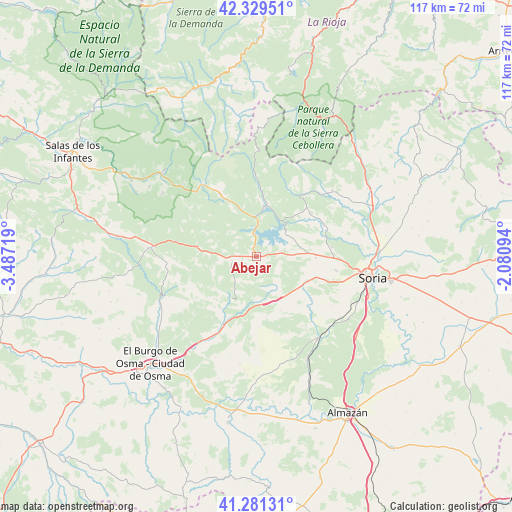
Abejar GPS coordinates[2]
41° 48' 27.18" North, 2° 47' 2.652" West
| Map corner | latitude | longitude |
|---|---|---|
| Upper-left | 42.32951°, | -3.48719° |
| Center: | 41.80755°, | -2.78407° |
| Lower-right: | 41.28131°, | -2.08094° |
| Map W x H: | 116.5×116.5 km | = 72.4×72.4mi |
| max Lat: | 43.74134° ⇑31.3% North |
| Abejar: | 41.80755° |
| min Lat: | ⇓68.7% South 27.64134° |
| min Long | Abejar | max Long |
| -18.00367° | -2.78407° | 4.2899° |
| W 57.7%⇐ | ⇒42.3% E |
Elevation
Elevation of Abejar is 1141 m = 3743 ft, and this is 543 m = 1781 ft above average elevation for this country.
| Max E: |
1682 m = 5518 ft | 4.9% |
| Abejar | 1141 m 3743 ft | |
| Avg. | 598 m = 1962 ft | |
Min E: |
0 m = 0 ft | 95.1% |
See also: Spain elevation on elevation.city.
Geographical zone
Abejar is located in North temperate zone (between Tropic of Cancer and the Arctic Circle). Distance of this Northern Tropic circle is 2042.6 km =1269.2 mi to South.| Distance of | km | miles | from Abejar |
|---|---|---|---|
| North Pole | 5358.5 | 3329.6 | to North |
| Arctic Circle | 2752.6 | 1710.4 | to North |
| Tropic Cancer | 2042.6 | 1269.2 | to South |
| Equator | 4648.6 | 2888.5 | to South |


Nearby cities:
15 places around Abejar: (largest is in red/bold)
• Blacos
15.4 km =9.6 mi,  203°
203°
• Cabrejas del Pinar
5.6 km =3.5 mi,  256°
256°
• Calatañazor
12.4 km =7.7 mi,  193°
193°
• Cidones
12 km =7.5 mi,  86°
86°
• Covaleda
16.4 km =10.2 mi,  329°
329°
• Cubilla
14.3 km =8.9 mi,  242°
242°
• Molinos de Duero
8.7 km =5.4 mi,  358°
358°
• Muriel Viejo
11.2 km =7 mi, 255°
• Muriel de la Fuente
11.3 km =7 mi,  213°
213°
• Navaleno
18.6 km =11.6 mi,  280°
280°
• Salduero
9.2 km =5.7 mi,  353°
353°
• Torreblacos
17.3 km =10.7 mi, 207°
• Vadillo
18.7 km =11.6 mi, 264°
• Villaciervos
14 km =8.7 mi,  111°
111°
• Vinuesa
11.5 km =7.1 mi,  7°
7°
Sources, notices
• [Note1] Compared only with cities in Spain existing in our database
• [Src1] Map data: © OpenStreetMap contributors (CC-BY-SA)
• [Src2] Other city data from geonames.org with taken over terms of usage.
• [Src3] Geographical zone / Annual Mean Temperature by Robert A. Rohde @ Wikipedia
