Calatañazor geodata
Calatañazor (Castille and León) is a seat of a third-order administrative division; located in Spain in Europe/Madrid (GMT+2) time zone. With population of 60 people, there are 6350 cities with bigger population in this country. Compared to other cities in Spain, 66% of cities are located further ↓South; 57.2% of cities are located further ←West and 91.7% of cities have lower elevation than Calatañazor. Note1
Administrative division(s):
- Level 1: Castille and León
- Level 2: Provincia de Soria
- Level 3: Calatañazor


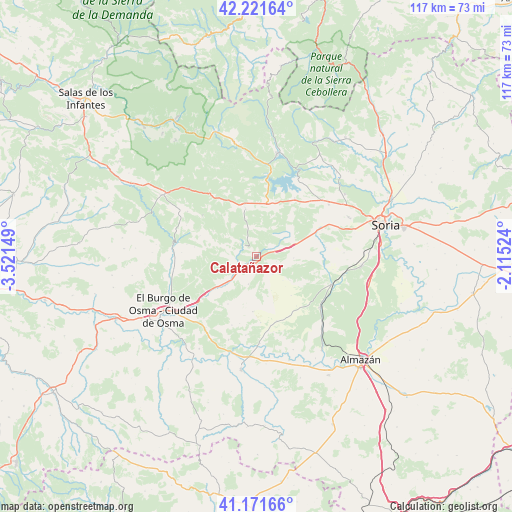
Calatañazor GPS coordinates[2]
41° 41' 55.644" North, 2° 49' 6.132" West
| Map corner | latitude | longitude |
|---|---|---|
| Upper-left | 42.22164°, | -3.52149° |
| Center: | 41.69879°, | -2.81837° |
| Lower-right: | 41.17166°, | -2.11524° |
| Map W x H: | 116.7×116.7 km | = 72.5×72.5mi |
| max Lat: | 43.74134° ⇑34% North |
| Calatañazor: | 41.69879° |
| min Lat: | ⇓66% South 27.64134° |
| min Long | Calatañazor | max Long |
| -18.00367° | -2.81837° | 4.2899° |
| W 57.2%⇐ | ⇒42.8% E |
Elevation
Elevation of Calatañazor is 1063 m = 3488 ft, and this is 465 m = 1526 ft above average elevation for this country.
| Max E: |
1682 m = 5518 ft | 8.3% |
| Calatañazor | 1063 m 3488 ft | |
| Avg. | 598 m = 1962 ft | |
Min E: |
0 m = 0 ft | 91.7% |
See also: Spain elevation on elevation.city.
Geographical zone
Calatañazor is located in North temperate zone (between Tropic of Cancer and the Arctic Circle). Distance of this Northern Tropic circle is 2030.6 km =1261.8 mi to South.| Distance of | km | miles | from Calatañazor |
|---|---|---|---|
| North Pole | 5370.6 | 3337.1 | to North |
| Arctic Circle | 2764.7 | 1717.9 | to North |
| Tropic Cancer | 2030.6 | 1261.8 | to South |
| Equator | 4636.5 | 2881 | to South |


Nearby cities:
15 places around Calatañazor: (largest is in red/bold)
• Abejar
12.4 km =7.7 mi,  13°
13°
• Bayubas de Arriba
16.7 km =10.4 mi,  200°
200°
• Blacos
3.9 km =2.4 mi,  239°
239°
• Cabrejas del Pinar
11.1 km =6.9 mi,  346°
346°
• Cubilla
11.3 km =7 mi,  299°
299°
• Fuentepinilla
15.4 km =9.6 mi,  162°
162°
• Herrera de Soria
17.6 km =10.9 mi,  293°
293°
• Muriel Viejo
12.3 km =7.6 mi,  319°
319°
• Muriel de la Fuente
4.4 km =2.7 mi,  308°
308°
• Quintana Redonda
18.2 km =11.3 mi,  111°
111°
• Tajueco
18.2 km =11.3 mi,  187°
187°
• Tardelcuende
18.6 km =11.6 mi,  128°
128°
• Torreblacos
6 km =3.7 mi, 236°
• Valderrodilla
15.1 km =9.4 mi,  176°
176°
• Villaciervos
17.4 km =10.8 mi,  66°
66°
Sources, notices
• [Note1] Compared only with cities in Spain existing in our database
• [Src1] Map data: © OpenStreetMap contributors (CC-BY-SA)
• [Src2] Other city data from geonames.org with taken over terms of usage.
• [Src3] Geographical zone / Annual Mean Temperature by Robert A. Rohde @ Wikipedia
