Bezares geodata
Bezares (La Rioja) is a seat of a third-order administrative division; located in Spain in Europe/Madrid (GMT+2) time zone. In our database, there are 6762 cities with bigger population. Compared to other cities in Spain, 83.8% of cities are located further ↓South; 58.9% of cities are located further ←West and 53.5% of cities have lower elevation than Bezares. Note1


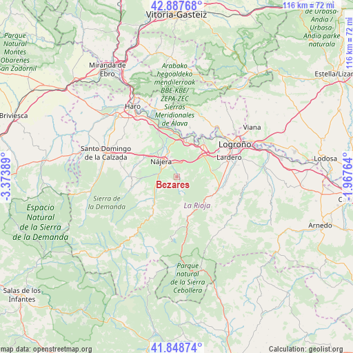
Bezares GPS coordinates[2]
42° 22' 13.296" North, 2° 40' 14.736" West
| Map corner | latitude | longitude |
|---|---|---|
| Upper-left | 42.88768°, | -3.37389° |
| Center: | 42.37036°, | -2.67076° |
| Lower-right: | 41.84874°, | -1.96764° |
| Map W x H: | 115.5×115.5 km | = 71.8×71.8mi |
| max Lat: | 43.74134° ⇑16.2% North |
| Bezares: | 42.37036° |
| min Lat: | ⇓83.8% South 27.64134° |
| min Long | Bezares | max Long |
| -18.00367° | -2.67076° | 4.2899° |
| W 58.9%⇐ | ⇒41.1% E |
Elevation
Elevation of Bezares is 696 m = 2283 ft, and this is 98 m = 322 ft above average elevation for this country.
| Max E: |
1682 m = 5518 ft | 46.5% |
| Bezares | 696 m 2283 ft | |
| Avg. | 598 m = 1962 ft | |
Min E: |
0 m = 0 ft | 53.5% |
See also: Spain elevation on elevation.city.
Geographical zone
Bezares is located in North temperate zone (between Tropic of Cancer and the Arctic Circle). Distance of this Northern Tropic circle is 2105.2 km =1308.1 mi to South.| Distance of | km | miles | from Bezares |
|---|---|---|---|
| North Pole | 5295.9 | 3290.7 | to North |
| Arctic Circle | 2690 | 1671.5 | to North |
| Tropic Cancer | 2105.2 | 1308.1 | to South |
| Equator | 4711.1 | 2927.3 | to South |


Nearby cities:
15 places around Bezares: (largest is in red/bold)
• Alesón
4.2 km =2.6 mi,  338°
338°
• Arenzana de Abajo
4.4 km =2.7 mi,  293°
293°
• Arenzana de Arriba
2.7 km =1.7 mi,  313°
313°
• Camproviín
4.7 km =2.9 mi,  246°
246°
• Castroviejo
4.6 km =2.9 mi,  170°
170°
• Cárdenas
7.9 km =4.9 mi,  273°
273°
• Daroca de Rioja
7.3 km =4.5 mi,  89°
89°
• Hornos de Moncalvillo
7.4 km =4.6 mi,  71°
71°
• Huércanos
6.7 km =4.2 mi, 342°
• Ledesma de la Cogolla
6.8 km =4.2 mi,  215°
215°
• Manjarrés
2.4 km =1.5 mi,  351°
351°
• Nájera
7.1 km =4.4 mi,  318°
318°
• Santa Coloma
1.3 km =0.8 mi,  106°
106°
• Tricio
5.3 km =3.3 mi, 311°
• Ventosa
5.3 km =3.3 mi,  43°
43°
Sources, notices
• [Note1] Compared only with cities in Spain existing in our database
• [Src1] Map data: © OpenStreetMap contributors (CC-BY-SA)
• [Src2] Other city data from geonames.org with taken over terms of usage.
• [Src3] Geographical zone / Annual Mean Temperature by Robert A. Rohde @ Wikipedia
