Huércanos geodata
Huércanos (La Rioja) is a seat of a third-order administrative division; located in Spain in Europe/Madrid (GMT+2) time zone. With population of 891 people, there are 3075 cities with bigger population in this country. Compared to other cities in Spain, 85.7% of cities are located further ↓South; 58.7% of cities are located further ←West and 61.2% of cities have higher elevation than Huércanos. Note1


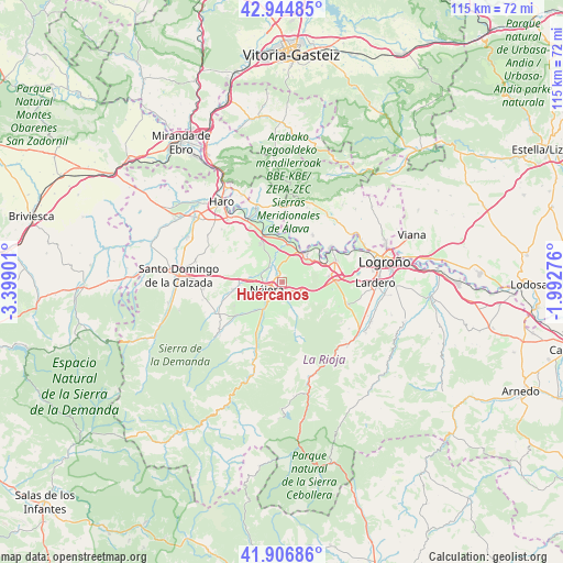
Huércanos GPS coordinates[2]
42° 25' 40.8" North, 2° 41' 45.204" West
| Map corner | latitude | longitude |
|---|---|---|
| Upper-left | 42.94485°, | -3.39901° |
| Center: | 42.428°, | -2.69589° |
| Lower-right: | 41.90686°, | -1.99276° |
| Map W x H: | 115.4×115.4 km | = 71.7×71.7mi |
| max Lat: | 43.74134° ⇑14.3% North |
| Huércanos: | 42.428° |
| min Lat: | ⇓85.7% South 27.64134° |
| min Long | Huércanos | max Long |
| -18.00367° | -2.69589° | 4.2899° |
| W 58.7%⇐ | ⇒41.3% E |
Elevation
Elevation of Huércanos is 509 m = 1670 ft, and this is 89 m = 292 ft below average elevation for this country.
| Max E: |
1682 m = 5518 ft | 61.2% |
| Avg. | 598 m = 1962 ft | |
| Huércanos | 509 m = 1670 ft | |
Min E: |
0 m = 0 ft | 38.8% |
See also: Spain elevation on elevation.city.
Geographical zone
Huércanos is located in North temperate zone (between Tropic of Cancer and the Arctic Circle). Distance of this Northern Tropic circle is 2111.6 km =1312.1 mi to South.| Distance of | km | miles | from Huércanos |
|---|---|---|---|
| North Pole | 5289.5 | 3286.7 | to North |
| Arctic Circle | 2683.6 | 1667.5 | to North |
| Tropic Cancer | 2111.6 | 1312.1 | to South |
| Equator | 4717.6 | 2931.4 | to South |


Nearby cities:
15 places around Huércanos: (largest is in red/bold)
• Alesón
2.6 km =1.6 mi,  167°
167°
• Arenzana de Abajo
5.1 km =3.2 mi,  202°
202°
• Arenzana de Arriba
4.5 km =2.8 mi,  179°
179°
• Bezares
6.7 km =4.2 mi,  162°
162°
• Cenicero
7.3 km =4.5 mi,  35°
35°
• Cárdenas
8.3 km =5.2 mi,  224°
224°
• Hormilla
6.5 km =4 mi,  280°
280°
• Hormilleja
4.3 km =2.7 mi,  317°
317°
• Manjarrés
4.4 km =2.7 mi, 157°
• Nájera
2.9 km =1.8 mi,  247°
247°
• Santa Coloma
7.5 km =4.7 mi,  154°
154°
• Torremontalbo
8.1 km =5 mi,  7°
7°
• Tricio
3.4 km =2.1 mi,  213°
213°
• Uruñuela
1.9 km =1.2 mi,  330°
330°
• Ventosa
6.2 km =3.9 mi,  114°
114°
Sources, notices
• [Note1] Compared only with cities in Spain existing in our database
• [Src1] Map data: © OpenStreetMap contributors (CC-BY-SA)
• [Src2] Other city data from geonames.org with taken over terms of usage.
• [Src3] Geographical zone / Annual Mean Temperature by Robert A. Rohde @ Wikipedia
