Manjarrés geodata
Manjarrés (La Rioja) is a seat of a third-order administrative division; located in Spain in Europe/Madrid (GMT+2) time zone. With population of 127 people, there are 5616 cities with bigger population in this country. Compared to other cities in Spain, 84.5% of cities are located further ↓South; 58.9% of cities are located further ←West and 52.4% of cities have higher elevation than Manjarrés. Note1


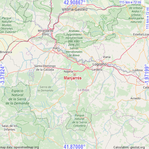
Manjarrés GPS coordinates[2]
42° 23' 29.472" North, 2° 40' 30.432" West
| Map corner | latitude | longitude |
|---|---|---|
| Upper-left | 42.90867°, | -3.37824° |
| Center: | 42.39152°, | -2.67512° |
| Lower-right: | 41.87008°, | -1.97199° |
| Map W x H: | 115.5×115.5 km | = 71.8×71.8mi |
| max Lat: | 43.74134° ⇑15.5% North |
| Manjarrés: | 42.39152° |
| min Lat: | ⇓84.5% South 27.64134° |
| min Long | Manjarrés | max Long |
| -18.00367° | -2.67512° | 4.2899° |
| W 58.9%⇐ | ⇒41.1% E |
Elevation
Elevation of Manjarrés is 632 m = 2073 ft, and this is 34 m = 112 ft above average elevation for this country.
| Max E: |
1682 m = 5518 ft | 52.4% |
| Manjarrés | 632 m 2073 ft | |
| Avg. | 598 m = 1962 ft | |
Min E: |
0 m = 0 ft | 47.6% |
See also: Spain elevation on elevation.city.
Geographical zone
Manjarrés is located in North temperate zone (between Tropic of Cancer and the Arctic Circle). Distance of this Northern Tropic circle is 2107.6 km =1309.6 mi to South.| Distance of | km | miles | from Manjarrés |
|---|---|---|---|
| North Pole | 5293.6 | 3289.3 | to North |
| Arctic Circle | 2687.7 | 1670.1 | to North |
| Tropic Cancer | 2107.6 | 1309.6 | to South |
| Equator | 4713.5 | 2928.8 | to South |


Nearby cities:
15 places around Manjarrés: (largest is in red/bold)
• Alesón
1.9 km =1.2 mi,  323°
323°
• Arenzana de Abajo
3.7 km =2.3 mi,  260°
260°
• Arenzana de Arriba
1.7 km =1.1 mi,  254°
254°
• Bezares
2.4 km =1.5 mi,  171°
171°
• Camproviín
5.7 km =3.5 mi,  223°
223°
• Castroviejo
7 km =4.3 mi, 170°
• Cárdenas
7.8 km =4.8 mi, 256°
• Daroca de Rioja
8 km =5 mi,  106°
106°
• Hornos de Moncalvillo
7.4 km =4.6 mi,  89°
89°
• Huércanos
4.4 km =2.7 mi,  337°
337°
• Nájera
5.3 km =3.3 mi,  304°
304°
• Santa Coloma
3.1 km =1.9 mi,  149°
149°
• Tricio
3.8 km =2.4 mi,  288°
288°
• Uruñuela
6.3 km =3.9 mi, 335°
• Ventosa
4.3 km =2.7 mi,  69°
69°
Sources, notices
• [Note1] Compared only with cities in Spain existing in our database
• [Src1] Map data: © OpenStreetMap contributors (CC-BY-SA)
• [Src2] Other city data from geonames.org with taken over terms of usage.
• [Src3] Geographical zone / Annual Mean Temperature by Robert A. Rohde @ Wikipedia
