Nájera geodata
Nájera (La Rioja) is a seat of a third-order administrative division; located in Spain in Europe/Madrid (GMT+2) time zone. With population of 7,789 people, there are 956 cities with bigger population in this country. Compared to other cities in Spain, 85.4% of cities are located further ↓South; 58.3% of cities are located further ←West and 62.2% of cities have higher elevation than Nájera. Note1


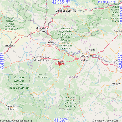
Nájera GPS coordinates[2]
42° 25' 5.592" North, 2° 43' 43.14" West
| Map corner | latitude | longitude |
|---|---|---|
| Upper-left | 42.93515°, | -3.43177° |
| Center: | 42.41822°, | -2.72865° |
| Lower-right: | 41.897°, | -2.02552° |
| Map W x H: | 115.4×115.4 km | = 71.7×71.7mi |
| max Lat: | 43.74134° ⇑14.6% North |
| Nájera: | 42.41822° |
| min Lat: | ⇓85.4% South 27.64134° |
| min Long | Nájera | max Long |
| -18.00367° | -2.72865° | 4.2899° |
| W 58.3%⇐ | ⇒41.7% E |
Elevation
Elevation of Nájera is 496 m = 1627 ft, and this is 102 m = 335 ft below average elevation for this country.
| Max E: |
1682 m = 5518 ft | 62.2% |
| Avg. | 598 m = 1962 ft | |
| Nájera | 496 m = 1627 ft | |
Min E: |
0 m = 0 ft | 37.8% |
See also: Spain elevation on elevation.city.
Geographical zone
Nájera is located in North temperate zone (between Tropic of Cancer and the Arctic Circle). Distance of this Northern Tropic circle is 2110.5 km =1311.4 mi to South.| Distance of | km | miles | from Nájera |
|---|---|---|---|
| North Pole | 5290.6 | 3287.4 | to North |
| Arctic Circle | 2684.7 | 1668.2 | to North |
| Tropic Cancer | 2110.5 | 1311.4 | to South |
| Equator | 4716.5 | 2930.7 | to South |


Nearby cities:
15 places around Nájera: (largest is in red/bold)
• Alesanco
7.2 km =4.5 mi,  266°
266°
• Alesón
3.5 km =2.2 mi,  113°
113°
• Arenzana de Abajo
3.7 km =2.3 mi,  168°
168°
• Arenzana de Arriba
4.4 km =2.7 mi,  141°
141°
• Azofra
6 km =3.7 mi,  276°
276°
• Bezares
7.1 km =4.4 mi, 138°
• Camproviín
7.2 km =4.5 mi,  176°
176°
• Cordovín
8 km =5 mi,  242°
242°
• Cárdenas
5.8 km =3.6 mi,  213°
213°
• Hormilla
4.4 km =2.7 mi,  300°
300°
• Hormilleja
4.2 km =2.6 mi,  356°
356°
• Huércanos
2.9 km =1.8 mi,  67°
67°
• Manjarrés
5.3 km =3.3 mi,  124°
124°
• Tricio
1.9 km =1.2 mi,  156°
156°
• Uruñuela
3.3 km =2.1 mi,  32°
32°
Sources, notices
• [Note1] Compared only with cities in Spain existing in our database
• [Src1] Map data: © OpenStreetMap contributors (CC-BY-SA)
• [Src2] Other city data from geonames.org with taken over terms of usage.
• [Src3] Geographical zone / Annual Mean Temperature by Robert A. Rohde @ Wikipedia
