Tricio geodata
Tricio (La Rioja) is a seat of a third-order administrative division; located in Spain in Europe/Madrid (GMT+2) time zone. With population of 373 people, there are 4231 cities with bigger population in this country. Compared to other cities in Spain, 84.8% of cities are located further ↓South; 58.4% of cities are located further ←West and 57.4% of cities have higher elevation than Tricio. Note1


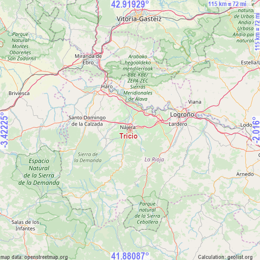
Tricio GPS coordinates[2]
42° 24' 8.028" North, 2° 43' 8.832" West
| Map corner | latitude | longitude |
|---|---|---|
| Upper-left | 42.91929°, | -3.42225° |
| Center: | 42.40223°, | -2.71912° |
| Lower-right: | 41.88087°, | -2.016° |
| Map W x H: | 115.5×115.5 km | = 71.8×71.8mi |
| max Lat: | 43.74134° ⇑15.2% North |
| Tricio: | 42.40223° |
| min Lat: | ⇓84.8% South 27.64134° |
| min Long | Tricio | max Long |
| -18.00367° | -2.71912° | 4.2899° |
| W 58.4%⇐ | ⇒41.6% E |
Elevation
Elevation of Tricio is 558 m = 1831 ft, and this is 40 m = 131 ft below average elevation for this country.
| Max E: |
1682 m = 5518 ft | 57.4% |
| Avg. | 598 m = 1962 ft | |
| Tricio | 558 m = 1831 ft | |
Min E: |
0 m = 0 ft | 42.6% |
See also: Spain elevation on elevation.city.
Geographical zone
Tricio is located in North temperate zone (between Tropic of Cancer and the Arctic Circle). Distance of this Northern Tropic circle is 2108.8 km =1310.3 mi to South.| Distance of | km | miles | from Tricio |
|---|---|---|---|
| North Pole | 5292.4 | 3288.5 | to North |
| Arctic Circle | 2686.5 | 1669.3 | to North |
| Tropic Cancer | 2108.8 | 1310.3 | to South |
| Equator | 4714.7 | 2929.6 | to South |


Nearby cities:
15 places around Tricio: (largest is in red/bold)
• Alesón
2.5 km =1.6 mi,  81°
81°
• Arenzana de Abajo
1.8 km =1.1 mi,  180°
180°
• Arenzana de Arriba
2.6 km =1.6 mi,  129°
129°
• Azofra
7.1 km =4.4 mi,  289°
289°
• Bezares
5.3 km =3.3 mi, 131°
• Camproviín
5.4 km =3.4 mi, 183°
• Cárdenas
5 km =3.1 mi,  232°
232°
• Hormilla
6.1 km =3.8 mi,  311°
311°
• Hormilleja
6.1 km =3.8 mi,  350°
350°
• Huércanos
3.4 km =2.1 mi,  33°
33°
• Manjarrés
3.8 km =2.4 mi,  108°
108°
• Nájera
1.9 km =1.2 mi,  336°
336°
• Santa Coloma
6.5 km =4 mi, 126°
• Uruñuela
4.6 km =2.9 mi,  11°
11°
• Ventosa
7.6 km =4.7 mi,  87°
87°
Sources, notices
• [Note1] Compared only with cities in Spain existing in our database
• [Src1] Map data: © OpenStreetMap contributors (CC-BY-SA)
• [Src2] Other city data from geonames.org with taken over terms of usage.
• [Src3] Geographical zone / Annual Mean Temperature by Robert A. Rohde @ Wikipedia
