Candelario geodata
Candelario (Castille and León) is a seat of a third-order administrative division; located in Spain in Europe/Madrid (GMT+2) time zone. With population of 1,026 people, there are 2903 cities with bigger population in this country. Compared to other cities in Spain, 64.5% of cities are located further ↑North; 82.5% of cities are located further →East and 92.8% of cities have lower elevation than Candelario. Note1
Administrative division(s):
- Level 1: Castille and León
- Level 2: Provincia de Salamanca
- Level 3: Candelario


Candelario GPS coordinates[2]
40° 22' 5.016" North, 5° 44' 41.964" West
| Map corner | latitude | longitude |
|---|---|---|
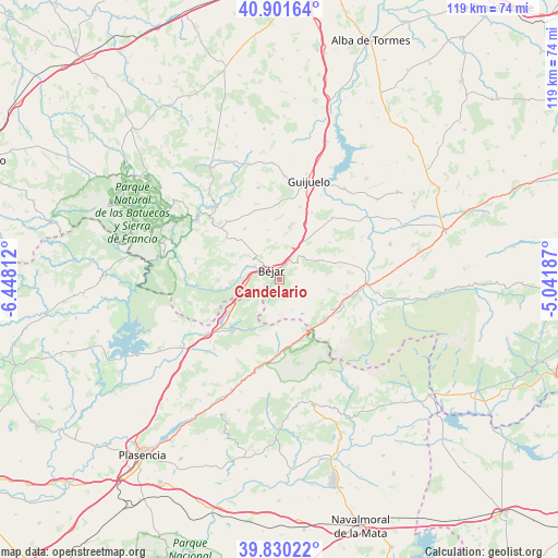
| Upper-left | 40.90164°, | -6.44812° |
| Center: | 40.36806°, | -5.74499° |
| Lower-right: | 39.83022°, | -5.04187° |
| Map W x H: | 119.1×119.1 km | = 74×74mi |
| max Lat: | 43.74134° ⇑64.5% North |
| Candelario: | 40.36806° |
| min Lat: | ⇓35.5% South 27.64134° |
| min Long | Candelario | max Long |
| -18.00367° | -5.74499° | 4.2899° |
| W 17.5%⇐ | ⇒82.5% E |
Elevation
Elevation of Candelario is 1088 m = 3570 ft, and this is 490 m = 1608 ft above average elevation for this country.
| Max E: |
1682 m = 5518 ft | 7.2% |
| Candelario | 1088 m 3570 ft | |
| Avg. | 598 m = 1962 ft | |
Min E: |
0 m = 0 ft | 92.8% |
See also: Spain elevation on elevation.city.
Geographical zone
Candelario is located in North temperate zone (between Tropic of Cancer and the Arctic Circle). Distance of this Northern Tropic circle is 1882.6 km =1169.8 mi to South.| Distance of | km | miles | from Candelario |
|---|---|---|---|
| North Pole | 5518.6 | 3429.1 | to North |
| Arctic Circle | 2912.7 | 1809.9 | to North |
| Tropic Cancer | 1882.6 | 1169.8 | to South |
| Equator | 4488.5 | 2789 | to South |


Nearby cities:
15 places around Candelario: (largest is in red/bold)
• Becedas
10.1 km =6.3 mi,  66°
66°
• Béjar
2.6 km =1.6 mi,  322°
322°
• Cantagallo
6.3 km =3.9 mi,  274°
274°
• Fresnedoso
8.1 km =5 mi,  21°
21°
• La Garganta
7.9 km =4.9 mi,  236°
236°
• Navacarros
4.2 km =2.6 mi,  38°
38°
• Navalmoral de Béjar
6.9 km =4.3 mi,  331°
331°
• Neila de San Miguel
10.1 km =6.3 mi,  52°
52°
• Peñacaballera
10.2 km =6.3 mi,  254°
254°
• Puerto de Béjar
8.1 km =5 mi,  256°
256°
• San Bartolomé de Béjar
8.3 km =5.2 mi,  57°
57°
• Sanchotello
7.8 km =4.8 mi,  354°
354°
• Sorihuela
10.1 km =6.3 mi,  33°
33°
• Valdehijaderos
10.4 km =6.5 mi,  303°
303°
• Vallejera de Riofrío
5.1 km =3.2 mi, 25°
Sources, notices
• [Note1] Compared only with cities in Spain existing in our database
• [Src1] Map data: © OpenStreetMap contributors (CC-BY-SA)
• [Src2] Other city data from geonames.org with taken over terms of usage.
• [Src3] Geographical zone / Annual Mean Temperature by Robert A. Rohde @ Wikipedia
