Avinyó geodata
Avinyó (Catalonia) is a seat of a third-order administrative division; located in Spain in Europe/Madrid (GMT+2) time zone. With population of 2,093 people, there are 2103 cities with bigger population in this country. Compared to other cities in Spain, 70.1% of cities are located further ↓South; 93.3% of cities are located further ←West and 70.9% of cities have higher elevation than Avinyó. Note1


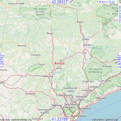
Avinyó GPS coordinates[2]
41° 51' 49.212" North, 1° 58' 15.42" East
| Map corner | latitude | longitude |
|---|---|---|
| Upper-left | 42.38517°, | 1.26782° |
| Center: | 41.86367°, | 1.97095° |
| Lower-right: | 41.33789°, | 2.67407° |
| Map W x H: | 116.4×116.4 km | = 72.3×72.3mi |
| max Lat: | 43.74134° ⇑29.9% North |
| Avinyó: | 41.86367° |
| min Lat: | ⇓70.1% South 27.64134° |
| min Long | Avinyó | max Long |
| -18.00367° | 1.97095° | 4.2899° |
| W 93.3%⇐ | ⇒6.7% E |
Elevation
Elevation of Avinyó is 369 m = 1211 ft, and this is 229 m = 751 ft below average elevation for this country.
| Max E: |
1682 m = 5518 ft | 70.9% |
| Avg. | 598 m = 1962 ft | |
| Avinyó | 369 m = 1211 ft | |
Min E: |
0 m = 0 ft | 29.1% |
See also: Spain elevation on elevation.city.
Geographical zone
Avinyó is located in North temperate zone (between Tropic of Cancer and the Arctic Circle). Distance of this Northern Tropic circle is 2048.9 km =1273.1 mi to South.| Distance of | km | miles | from Avinyó |
|---|---|---|---|
| North Pole | 5352.3 | 3325.8 | to North |
| Arctic Circle | 2746.4 | 1706.5 | to North |
| Tropic Cancer | 2048.9 | 1273.1 | to South |
| Equator | 4654.8 | 2892.4 | to South |


Nearby cities:
15 places around Avinyó: (largest is in red/bold)
• Artés
7.4 km =4.6 mi,  190°
190°
• Balsareny
8.1 km =5 mi,  269°
269°
• Calders
8.4 km =5.2 mi,  171°
171°
• Castellnou de Bages
11.5 km =7.1 mi,  253°
253°
• Moià
12.1 km =7.5 mi,  118°
118°
• Monistrol de Calders
12.1 km =7.5 mi,  161°
161°
• Navarcles
13.6 km =8.5 mi,  204°
204°
• Navàs
8.7 km =5.4 mi,  297°
297°
• Oristà
11.1 km =6.9 mi,  45°
45°
• Puig-reig
13.6 km =8.5 mi,  327°
327°
• Sallent
7.5 km =4.7 mi,  236°
236°
• Sant Feliu Sasserra
10.9 km =6.8 mi,  28°
28°
• Santa Maria d'Oló
5.2 km =3.2 mi,  86°
86°
• Santpedor
13.6 km =8.5 mi,  228°
228°
• Talamanca
14.1 km =8.8 mi,  177°
177°
Sources, notices
• [Note1] Compared only with cities in Spain existing in our database
• [Src1] Map data: © OpenStreetMap contributors (CC-BY-SA)
• [Src2] Other city data from geonames.org with taken over terms of usage.
• [Src3] Geographical zone / Annual Mean Temperature by Robert A. Rohde @ Wikipedia
