Navàs geodata
Navàs (Catalonia) is a populated place; located in Spain in Europe/Madrid (GMT+2) time zone. With population of 5,696 people, there are 1176 cities with bigger population in this country. Compared to other cities in Spain, 70.9% of cities are located further ↓South; 93% of cities are located further ←West and 70.3% of cities have higher elevation than Navàs. Note1


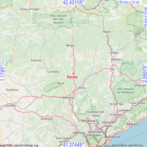
Navàs GPS coordinates[2]
41° 53' 59.928" North, 1° 52' 39.468" East
| Map corner | latitude | longitude |
|---|---|---|
| Upper-left | 42.42118°, | 1.1745° |
| Center: | 41.89998°, | 1.87763° |
| Lower-right: | 41.37449°, | 2.58075° |
| Map W x H: | 116.4×116.4 km | = 72.3×72.3mi |
| max Lat: | 43.74134° ⇑29.1% North |
| Navàs: | 41.89998° |
| min Lat: | ⇓70.9% South 27.64134° |
| min Long | Navàs | max Long |
| -18.00367° | 1.87763° | 4.2899° |
| W 93%⇐ | ⇒7% E |
Elevation
Elevation of Navàs is 376 m = 1234 ft, and this is 222 m = 728 ft below average elevation for this country.
| Max E: |
1682 m = 5518 ft | 70.3% |
| Avg. | 598 m = 1962 ft | |
| Navàs | 376 m = 1234 ft | |
Min E: |
0 m = 0 ft | 29.7% |
See also: Spain elevation on elevation.city.
Geographical zone
Navàs is located in North temperate zone (between Tropic of Cancer and the Arctic Circle). Distance of this Northern Tropic circle is 2052.9 km =1275.6 mi to South.| Distance of | km | miles | from Navàs |
|---|---|---|---|
| North Pole | 5348.2 | 3323.2 | to North |
| Arctic Circle | 2742.3 | 1704 | to North |
| Tropic Cancer | 2052.9 | 1275.6 | to South |
| Equator | 4658.8 | 2894.8 | to South |


Nearby cities:
15 places around Navàs: (largest is in red/bold)
• Artés
13 km =8.1 mi,  150°
150°
• Avinyó
8.7 km =5.4 mi,  117°
117°
• Balsareny
4.1 km =2.5 mi,  184°
184°
• Calders
15.3 km =9.5 mi,  143°
143°
• Callús
15.3 km =9.5 mi,  210°
210°
• Cardona
16.5 km =10.3 mi,  275°
275°
• Castellnou de Bages
8 km =5 mi,  204°
204°
• Gironella
14.9 km =9.3 mi,  0°
0°
• Oristà
16.1 km =10 mi,  76°
76°
• Puig-reig
7.4 km =4.6 mi, 3°
• Sallent
8.4 km =5.2 mi,  169°
169°
• Sant Feliu Sasserra
14 km =8.7 mi,  66°
66°
• Santa Maria d'Oló
13.4 km =8.3 mi,  106°
106°
• Santpedor
13.2 km =8.2 mi,  191°
191°
• Súria
12.9 km =8 mi,  234°
234°
Sources, notices
• [Note1] Compared only with cities in Spain existing in our database
• [Src1] Map data: © OpenStreetMap contributors (CC-BY-SA)
• [Src2] Other city data from geonames.org with taken over terms of usage.
• [Src3] Geographical zone / Annual Mean Temperature by Robert A. Rohde @ Wikipedia
