Sallent geodata
Sallent (Catalonia) is a seat of a third-order administrative division; located in Spain in Europe/Madrid (GMT+2) time zone. With population of 7,107 people, there are 1022 cities with bigger population in this country. Compared to other cities in Spain, 69.2% of cities are located further ↓South; 93.1% of cities are located further ←West and 75.6% of cities have higher elevation than Sallent. Note1


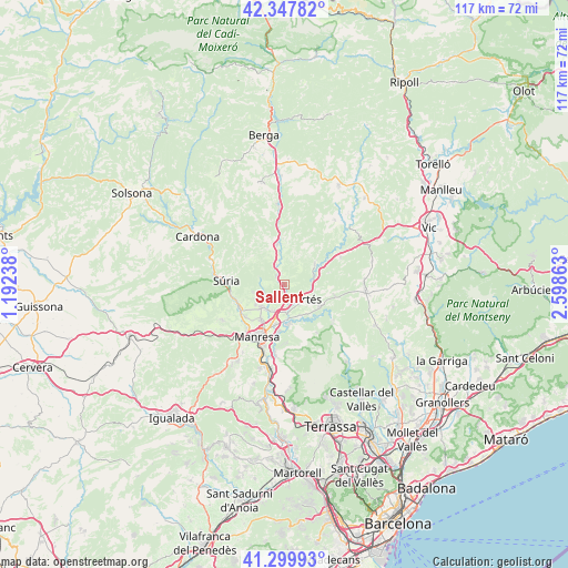
Sallent GPS coordinates[2]
41° 49' 33.672" North, 1° 53' 43.8" East
| Map corner | latitude | longitude |
|---|---|---|
| Upper-left | 42.34782°, | 1.19238° |
| Center: | 41.82602°, | 1.8955° |
| Lower-right: | 41.29993°, | 2.59863° |
| Map W x H: | 116.5×116.5 km | = 72.4×72.4mi |
| max Lat: | 43.74134° ⇑30.8% North |
| Sallent: | 41.82602° |
| min Lat: | ⇓69.2% South 27.64134° |
| min Long | Sallent | max Long |
| -18.00367° | 1.8955° | 4.2899° |
| W 93.1%⇐ | ⇒6.9% E |
Elevation
Elevation of Sallent is 290 m = 951 ft, and this is 308 m = 1010 ft below average elevation for this country.
| Max E: |
1682 m = 5518 ft | 75.6% |
| Avg. | 598 m = 1962 ft | |
| Sallent | 290 m = 951 ft | |
Min E: |
0 m = 0 ft | 24.4% |
See also: Spain elevation on elevation.city.
Geographical zone
Sallent is located in North temperate zone (between Tropic of Cancer and the Arctic Circle). Distance of this Northern Tropic circle is 2044.7 km =1270.5 mi to South.| Distance of | km | miles | from Sallent |
|---|---|---|---|
| North Pole | 5356.4 | 3328.3 | to North |
| Arctic Circle | 2750.6 | 1709.1 | to North |
| Tropic Cancer | 2044.7 | 1270.5 | to South |
| Equator | 4650.6 | 2889.7 | to South |


Nearby cities:
15 places around Sallent: (largest is in red/bold)
• Artés
5.8 km =3.6 mi,  122°
122°
• Avinyó
7.5 km =4.7 mi,  56°
56°
• Balsareny
4.5 km =2.8 mi,  336°
336°
• Calders
8.6 km =5.3 mi, 118°
• Callús
10.5 km =6.5 mi,  241°
241°
• Castellnou de Bages
4.9 km =3 mi,  280°
280°
• Monistrol de Calders
12.4 km =7.7 mi,  125°
125°
• Navarcles
8.3 km =5.2 mi,  175°
175°
• Navàs
8.4 km =5.2 mi,  349°
349°
• Sant Fruitós de Bages
8.8 km =5.5 mi,  195°
195°
• Sant Joan de Vilatorrada
11.7 km =7.3 mi,  220°
220°
• Santa Maria d'Oló
12.3 km =7.6 mi,  68°
68°
• Santpedor
6.3 km =3.9 mi, 220°
• Súria
12.1 km =7.5 mi,  273°
273°
• Talamanca
12 km =7.5 mi,  145°
145°
Sources, notices
• [Note1] Compared only with cities in Spain existing in our database
• [Src1] Map data: © OpenStreetMap contributors (CC-BY-SA)
• [Src2] Other city data from geonames.org with taken over terms of usage.
• [Src3] Geographical zone / Annual Mean Temperature by Robert A. Rohde @ Wikipedia
