Armallones geodata
Armallones (Castille-La Mancha) is a seat of a third-order administrative division; located in Spain in Europe/Madrid (GMT+2) time zone. With population of 60 people, there are 6350 cities with bigger population in this country. Compared to other cities in Spain, 57.4% of cities are located further ↑North; 63.4% of cities are located further ←West and 97.1% of cities have lower elevation than Armallones. Note1
Administrative division(s):
- Level 1: Castille-La Mancha
- Level 2: Provincia de Guadalajara
- Level 3: Armallones


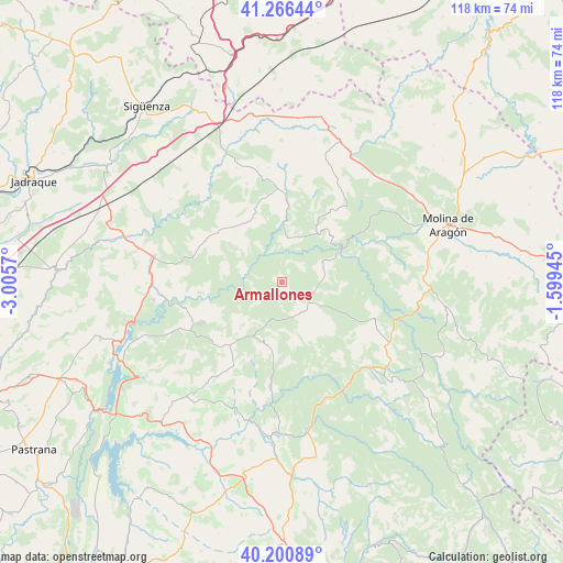
Armallones GPS coordinates[2]
40° 44' 8.88" North, 2° 18' 9.252" West
| Map corner | latitude | longitude |
|---|---|---|
| Upper-left | 41.26644°, | -3.0057° |
| Center: | 40.7358°, | -2.30257° |
| Lower-right: | 40.20089°, | -1.59945° |
| Map W x H: | 118.5×118.5 km | = 73.6×73.6mi |
| max Lat: | 43.74134° ⇑57.4% North |
| Armallones: | 40.7358° |
| min Lat: | ⇓42.6% South 27.64134° |
| min Long | Armallones | max Long |
| -18.00367° | -2.30257° | 4.2899° |
| W 63.4%⇐ | ⇒36.6% E |
Elevation
Elevation of Armallones is 1208 m = 3963 ft, and this is 610 m = 2001 ft above average elevation for this country.
| Max E: |
1682 m = 5518 ft | 2.9% |
| Armallones | 1208 m 3963 ft | |
| Avg. | 598 m = 1962 ft | |
Min E: |
0 m = 0 ft | 97.1% |
See also: Spain elevation on elevation.city.
Geographical zone
Armallones is located in North temperate zone (between Tropic of Cancer and the Arctic Circle). Distance of this Northern Tropic circle is 1923.5 km =1195.2 mi to South.| Distance of | km | miles | from Armallones |
|---|---|---|---|
| North Pole | 5477.7 | 3403.7 | to North |
| Arctic Circle | 2871.8 | 1784.5 | to North |
| Tropic Cancer | 1923.5 | 1195.2 | to South |
| Equator | 4529.4 | 2814.4 | to South |


Nearby cities:
15 places around Armallones: (largest is in red/bold)
• Ablanque
19.2 km =11.9 mi,  19°
19°
• Arbeteta
11.1 km =6.9 mi,  228°
228°
• Canredondo
18.2 km =11.3 mi,  297°
297°
• Esplegares
14.6 km =9.1 mi,  336°
336°
• Huertahernando
9.8 km =6.1 mi,  7°
7°
• Ocentejo
9 km =5.6 mi, 296°
• Olmeda de Cobeta
17.1 km =10.6 mi,  36°
36°
• Peralveche
18.6 km =11.6 mi,  221°
221°
• Riba de Saelices
19.5 km =12.1 mi,  1°
1°
• Sacecorbo
14.5 km =9 mi,  317°
317°
• Saelices de la Sal
19.1 km =11.9 mi,  354°
354°
• Valtablado del Río
8.7 km =5.4 mi,  254°
254°
• Villanueva de Alcorón
7.6 km =4.7 mi,  145°
145°
• Vindel
17.8 km =11.1 mi,  201°
201°
• Zaorejas
9 km =5.6 mi,  71°
71°
Sources, notices
• [Note1] Compared only with cities in Spain existing in our database
• [Src1] Map data: © OpenStreetMap contributors (CC-BY-SA)
• [Src2] Other city data from geonames.org with taken over terms of usage.
• [Src3] Geographical zone / Annual Mean Temperature by Robert A. Rohde @ Wikipedia
