Vindel geodata
Vindel (Castille-La Mancha) is a seat of a third-order administrative division; located in Spain in Europe/Madrid (GMT+2) time zone. With population of 30 people, there are 6661 cities with bigger population in this country. Compared to other cities in Spain, 60.1% of cities are located further ↑North; 62.6% of cities are located further ←West and 79.5% of cities have lower elevation than Vindel. Note1
Administrative division(s):
- Level 1: Castille-La Mancha
- Level 2: Provincia de Cuenca
- Level 3: Vindel


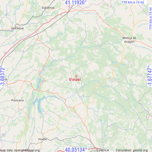
Vindel GPS coordinates[2]
40° 35' 14.748" North, 2° 22' 50.16" West
| Map corner | latitude | longitude |
|---|---|---|
| Upper-left | 41.11926°, | -3.08372° |
| Center: | 40.58743°, | -2.3806° |
| Lower-right: | 40.05134°, | -1.67747° |
| Map W x H: | 118.7×118.7 km | = 73.8×73.8mi |
| max Lat: | 43.74134° ⇑60.1% North |
| Vindel: | 40.58743° |
| min Lat: | ⇓39.9% South 27.64134° |
| min Long | Vindel | max Long |
| -18.00367° | -2.3806° | 4.2899° |
| W 62.6%⇐ | ⇒37.4% E |
Elevation
Elevation of Vindel is 893 m = 2930 ft, and this is 295 m = 968 ft above average elevation for this country.
| Max E: |
1682 m = 5518 ft | 20.5% |
| Vindel | 893 m 2930 ft | |
| Avg. | 598 m = 1962 ft | |
Min E: |
0 m = 0 ft | 79.5% |
See also: Spain elevation on elevation.city.
Geographical zone
Vindel is located in North temperate zone (between Tropic of Cancer and the Arctic Circle). Distance of this Northern Tropic circle is 1907 km =1185 mi to South.| Distance of | km | miles | from Vindel |
|---|---|---|---|
| North Pole | 5494.2 | 3413.9 | to North |
| Arctic Circle | 2888.3 | 1794.7 | to North |
| Tropic Cancer | 1907 | 1185 | to South |
| Equator | 4512.9 | 2804.2 | to South |


Nearby cities:
15 places around Vindel: (largest is in red/bold)
• Albendea
11.5 km =7.1 mi,  195°
195°
• Alcantud
6 km =3.7 mi,  137°
137°
• Arandilla del Arroyo
8.6 km =5.3 mi,  181°
181°
• Arbeteta
9.4 km =5.8 mi,  348°
348°
• Castilforte
5.5 km =3.4 mi,  232°
232°
• Cañizares
17.7 km =11 mi,  115°
115°
• Escamilla
16 km =9.9 mi,  254°
254°
• Peralveche
6.4 km =4 mi,  294°
294°
• Priego
16.3 km =10.1 mi,  159°
159°
• Salmerón
10.6 km =6.6 mi,  243°
243°
• San Pedro Palmiches
17.7 km =11 mi,  186°
186°
• Valdeolivas
10.6 km =6.6 mi,  211°
211°
• Valtablado del Río
14.2 km =8.8 mi, 352°
• Villanueva de Alcorón
15 km =9.3 mi,  46°
46°
• Villar del Infantado
16.9 km =10.5 mi, 209°
Sources, notices
• [Note1] Compared only with cities in Spain existing in our database
• [Src1] Map data: © OpenStreetMap contributors (CC-BY-SA)
• [Src2] Other city data from geonames.org with taken over terms of usage.
• [Src3] Geographical zone / Annual Mean Temperature by Robert A. Rohde @ Wikipedia
