Argente geodata
Argente (Aragon) is a seat of a third-order administrative division; located in Spain in Europe/Madrid (GMT+2) time zone. With population of 254 people, there are 4719 cities with bigger population in this country. Compared to other cities in Spain, 58.2% of cities are located further ↑North; 75.9% of cities are located further ←West and 97.9% of cities have lower elevation than Argente. Note1


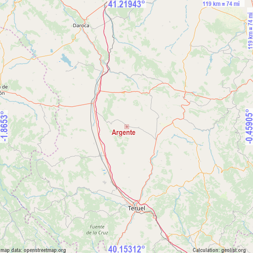
Argente GPS coordinates[2]
40° 41' 18.276" North, 1° 9' 43.812" West
| Map corner | latitude | longitude |
|---|---|---|
| Upper-left | 41.21943°, | -1.8653° |
| Center: | 40.68841°, | -1.16217° |
| Lower-right: | 40.15312°, | -0.45905° |
| Map W x H: | 118.6×118.6 km | = 73.7×73.7mi |
| max Lat: | 43.74134° ⇑58.2% North |
| Argente: | 40.68841° |
| min Lat: | ⇓41.8% South 27.64134° |
| min Long | Argente | max Long |
| -18.00367° | -1.16217° | 4.2899° |
| W 75.9%⇐ | ⇒24.1% E |
Elevation
Elevation of Argente is 1249 m = 4098 ft, and this is 651 m = 2136 ft above average elevation for this country.
| Max E: |
1682 m = 5518 ft | 2.1% |
| Argente | 1249 m 4098 ft | |
| Avg. | 598 m = 1962 ft | |
Min E: |
0 m = 0 ft | 97.9% |
See also: Spain elevation on elevation.city.
Geographical zone
Argente is located in North temperate zone (between Tropic of Cancer and the Arctic Circle). Distance of this Northern Tropic circle is 1918.2 km =1191.9 mi to South.| Distance of | km | miles | from Argente |
|---|---|---|---|
| North Pole | 5482.9 | 3406.9 | to North |
| Arctic Circle | 2877 | 1787.7 | to North |
| Tropic Cancer | 1918.2 | 1191.9 | to South |
| Equator | 4524.1 | 2811.1 | to South |


Nearby cities:
15 places around Argente: (largest is in red/bold)
• Aguatón
6.4 km =4 mi,  252°
252°
• Alpeñés
14.8 km =9.2 mi,  33°
33°
• Bañón
16.8 km =10.4 mi,  351°
351°
• Bueña
9.2 km =5.7 mi,  284°
284°
• Camañas
5.5 km =3.4 mi,  157°
157°
• Cosa
16.3 km =10.1 mi,  7°
7°
• Fuentes Calientes
16.5 km =10.3 mi,  85°
85°
• Lidón
5.3 km =3.3 mi,  52°
52°
• Pancrudo
13.9 km =8.6 mi, 53°
• Perales del Alfambra
14.8 km =9.2 mi,  114°
114°
• Rillo
14.5 km =9 mi,  74°
74°
• Rubielos de la Cérida
10.1 km =6.3 mi,  334°
334°
• Singra
13.1 km =8.1 mi, 253°
• Villafranca del Campo
15.6 km =9.7 mi,  272°
272°
• Visiedo
5.5 km =3.4 mi, 93°
Sources, notices
• [Note1] Compared only with cities in Spain existing in our database
• [Src1] Map data: © OpenStreetMap contributors (CC-BY-SA)
• [Src2] Other city data from geonames.org with taken over terms of usage.
• [Src3] Geographical zone / Annual Mean Temperature by Robert A. Rohde @ Wikipedia
