Singra geodata
Singra (Aragon) is a seat of a third-order administrative division; located in Spain in Europe/Madrid (GMT+2) time zone. With population of 97 people, there are 5975 cities with bigger population in this country. Compared to other cities in Spain, 58.8% of cities are located further ↑North; 74.7% of cities are located further ←West and 90% of cities have lower elevation than Singra. Note1


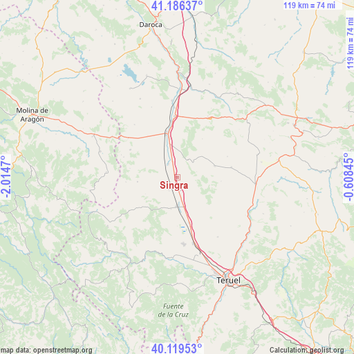
Singra GPS coordinates[2]
40° 39' 18.288" North, 1° 18' 41.688" West
| Map corner | latitude | longitude |
|---|---|---|
| Upper-left | 41.18637°, | -2.0147° |
| Center: | 40.65508°, | -1.31158° |
| Lower-right: | 40.11953°, | -0.60845° |
| Map W x H: | 118.6×118.6 km | = 73.7×73.7mi |
| max Lat: | 43.74134° ⇑58.8% North |
| Singra: | 40.65508° |
| min Lat: | ⇓41.2% South 27.64134° |
| min Long | Singra | max Long |
| -18.00367° | -1.31158° | 4.2899° |
| W 74.7%⇐ | ⇒25.3% E |
Elevation
Elevation of Singra is 1031 m = 3383 ft, and this is 433 m = 1421 ft above average elevation for this country.
| Max E: |
1682 m = 5518 ft | 10% |
| Singra | 1031 m 3383 ft | |
| Avg. | 598 m = 1962 ft | |
Min E: |
0 m = 0 ft | 90% |
See also: Spain elevation on elevation.city.
Geographical zone
Singra is located in North temperate zone (between Tropic of Cancer and the Arctic Circle). Distance of this Northern Tropic circle is 1914.5 km =1189.6 mi to South.| Distance of | km | miles | from Singra |
|---|---|---|---|
| North Pole | 5486.6 | 3409.2 | to North |
| Arctic Circle | 2880.8 | 1790 | to North |
| Tropic Cancer | 1914.5 | 1189.6 | to South |
| Equator | 4520.4 | 2808.8 | to South |


Nearby cities:
15 places around Singra: (largest is in red/bold)
• Aguatón
6.7 km =4.2 mi,  74°
74°
• Alba
5 km =3.1 mi,  215°
215°
• Almohaja
12 km =7.5 mi,  242°
242°
• Argente
13.1 km =8.1 mi, 73°
• Bueña
7 km =4.3 mi,  31°
31°
• Camañas
14.7 km =9.1 mi,  95°
95°
• Monreal del Campo
15.2 km =9.4 mi,  345°
345°
• Peracense
13.5 km =8.4 mi,  263°
263°
• Pozondón
17 km =10.6 mi,  232°
232°
• Rubielos de la Cérida
15.3 km =9.5 mi, 32°
• Ródenas
17.3 km =10.7 mi, 264°
• Santa Eulalia
9.7 km =6 mi,  180°
180°
• Villafranca del Campo
5.4 km =3.4 mi,  326°
326°
• Villar del Salz
16.1 km =10 mi,  280°
280°
• Villarquemado
15.8 km =9.8 mi,  165°
165°
Sources, notices
• [Note1] Compared only with cities in Spain existing in our database
• [Src1] Map data: © OpenStreetMap contributors (CC-BY-SA)
• [Src2] Other city data from geonames.org with taken over terms of usage.
• [Src3] Geographical zone / Annual Mean Temperature by Robert A. Rohde @ Wikipedia
