Bueña geodata
Bueña (Aragon) is a seat of a third-order administrative division; located in Spain in Europe/Madrid (GMT+2) time zone. With population of 73 people, there are 6214 cities with bigger population in this country. Compared to other cities in Spain, 57.8% of cities are located further ↑North; 75.1% of cities are located further ←West and 97.6% of cities have lower elevation than Bueña. Note1


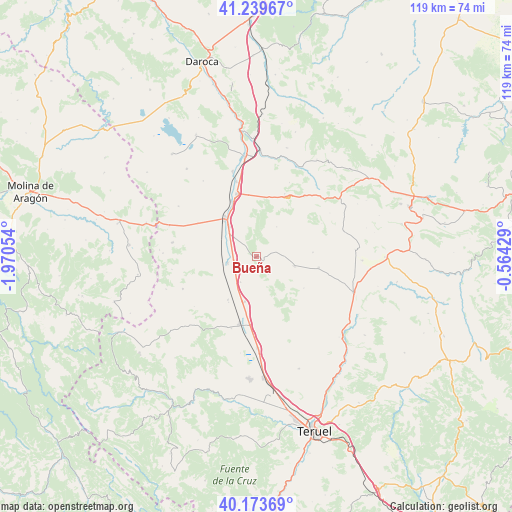
Bueña GPS coordinates[2]
40° 42' 31.716" North, 1° 16' 2.712" West
| Map corner | latitude | longitude |
|---|---|---|
| Upper-left | 41.23967°, | -1.97054° |
| Center: | 40.70881°, | -1.26742° |
| Lower-right: | 40.17369°, | -0.56429° |
| Map W x H: | 118.5×118.5 km | = 73.6×73.6mi |
| max Lat: | 43.74134° ⇑57.8% North |
| Bueña: | 40.70881° |
| min Lat: | ⇓42.2% South 27.64134° |
| min Long | Bueña | max Long |
| -18.00367° | -1.26742° | 4.2899° |
| W 75.1%⇐ | ⇒24.9% E |
Elevation
Elevation of Bueña is 1231 m = 4039 ft, and this is 633 m = 2077 ft above average elevation for this country.
| Max E: |
1682 m = 5518 ft | 2.4% |
| Bueña | 1231 m 4039 ft | |
| Avg. | 598 m = 1962 ft | |
Min E: |
0 m = 0 ft | 97.6% |
See also: Spain elevation on elevation.city.
Geographical zone
Bueña is located in North temperate zone (between Tropic of Cancer and the Arctic Circle). Distance of this Northern Tropic circle is 1920.5 km =1193.3 mi to South.| Distance of | km | miles | from Bueña |
|---|---|---|---|
| North Pole | 5480.7 | 3405.5 | to North |
| Arctic Circle | 2874.8 | 1786.3 | to North |
| Tropic Cancer | 1920.5 | 1193.3 | to South |
| Equator | 4526.4 | 2812.6 | to South |


Nearby cities:
15 places around Bueña: (largest is in red/bold)
• Aguatón
5 km =3.1 mi,  146°
146°
• Alba
12.1 km =7.5 mi,  213°
213°
• Argente
9.2 km =5.7 mi,  104°
104°
• Bañón
15.8 km =9.8 mi,  24°
24°
• Camañas
13.2 km =8.2 mi,  123°
123°
• Caminreal
15.2 km =9.4 mi,  341°
341°
• Cosa
17.7 km =11 mi,  38°
38°
• Lidón
13.1 km =8.1 mi,  85°
85°
• Monreal del Campo
11.5 km =7.1 mi,  319°
319°
• Rubielos de la Cérida
8.3 km =5.2 mi,  33°
33°
• Santa Eulalia
16.2 km =10.1 mi,  193°
193°
• Singra
7 km =4.3 mi, 211°
• Torrijo del Campo
14.3 km =8.9 mi, 335°
• Villafranca del Campo
6.9 km =4.3 mi,  257°
257°
• Visiedo
14.6 km =9.1 mi, 100°
Sources, notices
• [Note1] Compared only with cities in Spain existing in our database
• [Src1] Map data: © OpenStreetMap contributors (CC-BY-SA)
• [Src2] Other city data from geonames.org with taken over terms of usage.
• [Src3] Geographical zone / Annual Mean Temperature by Robert A. Rohde @ Wikipedia
