Bañón geodata
Bañón (Aragon) is a seat of a third-order administrative division; located in Spain in Europe/Madrid (GMT+2) time zone. With population of 179 people, there are 5189 cities with bigger population in this country. Compared to other cities in Spain, 55.3% of cities are located further ↑North; 75.8% of cities are located further ←West and 94.3% of cities have lower elevation than Bañón. Note1


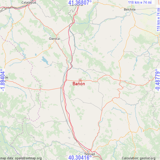
Bañón GPS coordinates[2]
40° 50' 17.7" North, 1° 11' 27.276" West
| Map corner | latitude | longitude |
|---|---|---|
| Upper-left | 41.36807°, | -1.89404° |
| Center: | 40.83825°, | -1.19091° |
| Lower-right: | 40.30416°, | -0.48779° |
| Map W x H: | 118.3×118.3 km | = 73.5×73.5mi |
| max Lat: | 43.74134° ⇑55.3% North |
| Bañón: | 40.83825° |
| min Lat: | ⇓44.7% South 27.64134° |
| min Long | Bañón | max Long |
| -18.00367° | -1.19091° | 4.2899° |
| W 75.8%⇐ | ⇒24.2% E |
Elevation
Elevation of Bañón is 1122 m = 3681 ft, and this is 524 m = 1719 ft above average elevation for this country.
| Max E: |
1682 m = 5518 ft | 5.7% |
| Bañón | 1122 m 3681 ft | |
| Avg. | 598 m = 1962 ft | |
Min E: |
0 m = 0 ft | 94.3% |
See also: Spain elevation on elevation.city.
Geographical zone
Bañón is located in North temperate zone (between Tropic of Cancer and the Arctic Circle). Distance of this Northern Tropic circle is 1934.9 km =1202.3 mi to South.| Distance of | km | miles | from Bañón |
|---|---|---|---|
| North Pole | 5466.3 | 3396.6 | to North |
| Arctic Circle | 2860.4 | 1777.4 | to North |
| Tropic Cancer | 1934.9 | 1202.3 | to South |
| Equator | 4540.8 | 2821.5 | to South |


Nearby cities:
15 places around Bañón: (largest is in red/bold)
• Alpeñés
11.3 km =7 mi,  112°
112°
• Barrachina
7.9 km =4.9 mi,  34°
34°
• Bueña
15.8 km =9.8 mi,  204°
204°
• Calamocha
12.7 km =7.9 mi,  315°
315°
• Caminreal
11.2 km =7 mi,  270°
270°
• Cosa
4.6 km =2.9 mi,  96°
96°
• Fuenferrada
15.5 km =9.6 mi,  77°
77°
• Fuentes Claras
11.4 km =7.1 mi,  284°
284°
• Lidón
15 km =9.3 mi,  153°
153°
• Monreal del Campo
14.9 km =9.3 mi,  248°
248°
• Pancrudo
16 km =9.9 mi,  121°
121°
• Rubielos de la Cérida
7.7 km =4.8 mi,  193°
193°
• Torre los Negros
8 km =5 mi, 78°
• Torrecilla del Rebollar
12.7 km =7.9 mi,  51°
51°
• Torrijo del Campo
12.4 km =7.7 mi,  263°
263°
Sources, notices
• [Note1] Compared only with cities in Spain existing in our database
• [Src1] Map data: © OpenStreetMap contributors (CC-BY-SA)
• [Src2] Other city data from geonames.org with taken over terms of usage.
• [Src3] Geographical zone / Annual Mean Temperature by Robert A. Rohde @ Wikipedia
